Trg Herceg Stjepana from Herceg Novi, Montenegro

Herceg Novi (Castelnuovo in Italian) is not new as the name claims, but rather quite old, for it was founded in 1382 on the site of a fishing village by the Bosnian King Stephen I, which is also the name of this town’s central square. The Turks conquered the town in 1482 and remained there for two centuries, with a brief Spanish interlude. The town came under Venetian rule in 1687, then passed to Austro-Hungary. After that, Herceg Novi was temporarily ruled by Napoleon, the Russians, and Mussolini, and then became part of Yugoslavia. Its history, though not in its entirety, can be found in its square. It is paradoxical square, for it was built in a typically Italian style, with a splendid Orthodox church in the middle, surrounded by palm trees. Unofficially, the name of the square is Belavista. From there the sea is visible, as well as an Ottoman clock tower, a Spanish fortress, the bell tower of the Catholic church and the lower part of the city.

Náměstí Svornosti from Český Krumlov, Czech Republic

Náměstí Svornosti is a small, 45 x 60 meter square. Beautiful but unexceptional, grouping a number of houses with Renaissance façades, it has a baroque column and is bounded on one side by the arches of the old City Hall building. The town, called Krumau in German, grew around the splendid castle, whose first historical mention is encountered in a 13th century poem. The castle has always remained the focal point, whilst the square held a secondary role, which accounts for its size, also determined by its location on a bend of the Vltava river. But it too remains a key element in the fairy-tale like atmosphere of the settlement, which has become renowned across the world and, thus, invaded by far too many tourists for such a small town.

Marktplatz from Elburg, Holland

Elburg’s square is the result of an intersection between two main arteries, and reproduces on a much smaller scale the quadrangular shape of the city. Elburg has perfect geometrical proportions, thought out in such a way that its measurements link to the golden number[MOU1] . The city, whose shape has remained unchanged, was built between 1392 and 1396, and is unusual for the Middle Ages, as all of its roads are linked both to the city’s edges and to its square, which lies exactly at the geometric centre of the quadrangle.

Praça Francisco Rodrigues Lobo from Leira, Portugal

This square has an important role in the social and economic life of the Leira community, for it is filled with cafes and terraces, where numerous events are organised. The square’s pavement is considered one of the most beautiful in Portugal. In medieval times, the square held seasonal fairs.

Náměstí Přemysla Otakara II from Český Budějovice, Czech Republic

This square is among the largest in Europe, and bears the name of King Ottokar II of Bohemia, who in 1256 founded the town, called Budweis in German. The Black Tower, built in the 16th century, and the Cathedral of Saint Nicholas are found in its south-eastern corner. The Baroque City Hall building lies at the opposite corner of the square, whilst its central point is occupied by Samson’s Fountain, featuring elaborate Baroque decorations. Completing the square are 48 houses with coats of arms; a beer factory; and a salt market.

Plaza Mayor from Cáceres, Spain

This is one of the largest squares in Spain and lies right at the entrance of the medieval town. Its origins are found in the 11thcentury, when the space was used for the great traditional holidays. The buildings are from different eras, with all of them having a 16th century ground floor colonnade. On the northwestern side, the Bujaco Tower is an eye-catching building, now a symbol of the city. It was built during the Arab rule, on top of Roman foundations. The origins of its name may come from the local word for straw dolls, bujacos.

Plazas de Europa

The lives of European squares vary from city to city, country to country, culture to culture. It is nearly midnight; while a lone traveler might be hurrying home across an empty square in northern Germany, the squares in the Iberian Peninsula are just waking up, as people emerge to eat, drink, and catch each other up on their days. In winter the contrast is not as sharp, as bustling Christmas fairs enliven the northern squares, while the south slows down somewhat. The squares of all European cities pass from season to season through various rhythms and rituals, showing their many faces. But squares can be divided into even more complex categories than northern and southern. Positioned on a map, it can be seen that the squares with a richer historic and aesthetic presence tend to be found in specific regions, forming a sort of network. Long before the Internet, cities were tied to one another through invisible connections, creating somewhat similar urban ‘networks’. 

Italy is by definition the land of squares. Many squares regarded as masterpieces are found north of Rome. Northern Italy boasts a higher number of squares per city, at times ingeniously interconnected. The South might have relatively fewer squares, but they are no less noteworthy. While it is difficult to find an unknown square in Italy, I have included here a few lesser-known squares of interest to the history of urbanism, such as Palmanova, or the narrow square in the tiny medieval settlement of Pitigliano. 

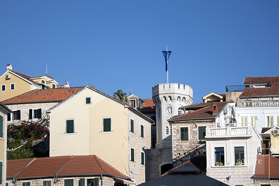
Across the Adriatic, the squares of the Dalmatian Coast have been severely overlooked. Once under the rule of the Republic of Venice (though some settlements date back even further), foreign encounters, particularly with southern Slavic cultures, have left their mark on the local squares. Cities throughout Slovenia, Croatia and Montenegro host such squares, but one finds fascinating squares all throughout the Balkans.

 The historic squares of Central Europe, north of the Alps and throughout the former Austro-Hungarian Empire, are a few centuries younger than their Italian counterparts. While visibly influenced by their predecessors, the unique characteristics of the central European squares are not obscured. It may seem surprising that most of these squares are found outside the powerful centre of Austria, but German colonists, deployed by Austro-Hungary, arriving in the early Middle Ages established many of these settlements. The Czech government has recognised more than forty historical cities in Bohemia and Moravia as urban heritage reservations– cities that developed around large, beautiful squares. Although fewer in number, squares throughout Slovakia, Slovenia, Hungary, and Romania follow the same template. Paradoxically, the central European squares are less ‘sophisticated’ than those in Germany proper, as can be seen by comparing them with some medieval squares that have survived the Second World War bombings, including ones in the Harz Mountains, among others. 

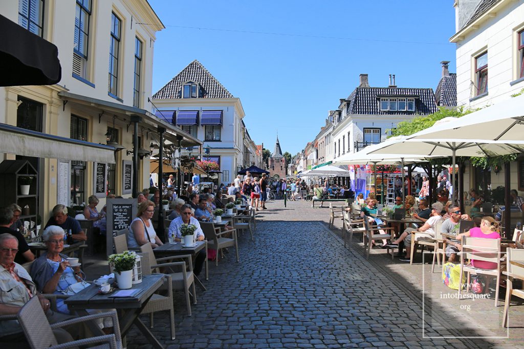
Another area containing special squares is the aforementioned Iberian Peninsula. Spain and Portugal are both countries with ‘dynamic’ squares. Each Spanish settlement, no matter how small, has a Plaza Mayor, which, quite late in the evening, becomes alive and remains alive until deep into the night: a community and family life that can be glimpsed in the rest of Europe through old photos.

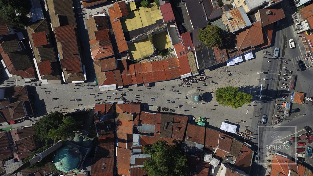
Even when squares are ‘cultural imports’ as recent as the 19th and 20th centuries – such as those in Balkan cities or in the Caucasian countries between the Black Sea and the Caspian Sea – they demonstrate an interesting synthesis of local traditions and histories. Tbilisi, the capital of Georgia, an ancient rest stop for caravans travelling along the Silk Road, has the Meidan square or Vahtang Gorgasali, originally a bazaar on the trade route. 

To a certain degree the selection of squares to be presented was subjective, however these squares are also among the best examples I was able to find to illustrate the historical, conservation, and urbanistic arguments presented on this website. I relentlessly favoured the lesser known and less travelled squares, although some famous squares do appear in the following pages. A number of European countries significant to the study of squares are missing for a technical reason: drone photography is not legally possible and, in the meantime, in many of the countries where I had taken images, drone photography has become restricted for legal reasons.

Marktplein from Bourtange, Netherlands

Today this is a village, with 133 houses and fewer than 300 inhabitants. Yet Bourtange was built as a military fort in 1593, during the Dutch Revolt, on the orders of William the Silent. It held this role until 1851, when it officially lost its defensive function and became populated by craftsmen and farmers. Its initial purpose was to guard the road linking Spanish Groningen to Germany. It is one of the most spectacular star-shaped forts in Europe. The pentagonal plan and its network of canals and fortifications respects the original project. The square stands in the geometric middle and follows the pentagonal shape of the buildings placed within the fort. Its perimeter is perfectly defined by 14 lime trees which are over 300 years old. The square holds the most important houses: the captain’s house, the commander’s house, and the house of the school headmaster, for the placement of its buildings was hierarchical. The Protestant church dates from 1869 and, notably, is situated close to the square but not within the square itself.

Praça de São João from Almeida, Portugal

On the Portuguese side of the border there are even more fortifications than in Spain. Almeida is found in the north of Portugal. It is a star-shaped fort with 12 corners, Vauban style, built in 1641. The Spanish only entered there once in all their history, and then with the help of the French. The square is an irregular quadrilateral and is not positioned quite geometrically, just as the star is not perfect; but its role as a centre is obvious when viewed in relation to the margins of the citadel.


Praça 8 de Maio from Coimbra, Portugal

Coimbra is famous for its university, and monumental squares are located in the university area. The city also possesses a small jewel of a square, modest in size but convincing through its balanced proportions and its historical importance. It is Praça 8 de Maio, found in the city centre, in front of the monastery of Santa Cruz, while further on one finds the Câmara Municipal. This small space manages to not be dwarfed by the height and splendour of the Manueline façade of the church where the first two kings of Portugal lie buried. The buildings on the other three sides are just as visible, likewise the central fountain. The contemporary redesigning of the square also contributes to its openness.

Praça do Municipio from Lisbon, Portugal

At a short distance from the monumental Praça do Comércio stands the municipal square, which hosts three important buildings: the Municipality, the Court of Appeals and the Naval Arsenal. It is a small, quiet square, with different rhythms from the Praça do Comércio, which, following the Rua do Arsenal, stands less than 70 meters ahead. Praça do Municipio is equally part of the urban fabric woven from the city’s reconstruction under the guidance of the Marquise of Pombal. This historical detail is enough to make it clear that they must be understood as counterpoints, that is, as parts of a broader, interconnected system of squares.

Plaza Mayor from Ciudad Rodrigo, Spain

This town took its name from Count Rodrigo González Girón. It was he who, in the mid-12th century, banished the Moors from this region once and for all, and built this town on top of a former Roman castrum, itself built atop a Celtic settlement. Its solid fortifications speak to its position on the border with Portugal. Paradoxically, although it is one of the most well-defended European borders on both sides, this frontier was the most stable in all of Europe’s history and has remained this way for 500 years. The only fighting to take place here was against Napoleon’s armies. Nowhere is the relationship between centre and periphery more marked than in such citadels.