On the Portuguese side of the border there are even more fortifications than in Spain. Almeida is found in the north of Portugal. It is a star-shaped fort with 12 corners, Vauban style, built in 1641. The Spanish only entered there once in all their history, and then with the help of the French. The square is an irregular quadrilateral and is not positioned quite geometrically, just as the star is not perfect; but its role as a centre is obvious when viewed in relation to the margins of the citadel.
Coimbra is famous for its university, and monumental squares are located in the university area. The city also possesses a small jewel of a square, modest in size but convincing through its balanced proportions and its historical importance. It is Praça 8 de Maio, found in the city centre, in front of the monastery of Santa Cruz, while further on one finds the Câmara Municipal. This small space manages to not be dwarfed by the height and splendour of the Manueline façade of the church where the first two kings of Portugal lie buried. The buildings on the other three sides are just as visible, likewise the central fountain. The contemporary redesigning of the square also contributes to its openness.
At a short distance from the monumental Praça do Comércio stands the municipal square, which hosts three important buildings: the Municipality, the Court of Appeals and the Naval Arsenal. It is a small, quiet square, with different rhythms from the Praça do Comércio, which, following the Rua do Arsenal, stands less than 70 meters ahead. Praça do Municipio is equally part of the urban fabric woven from the city’s reconstruction under the guidance of the Marquise of Pombal. This historical detail is enough to make it clear that they must be understood as counterpoints, that is, as parts of a broader, interconnected system of squares.
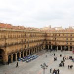
The construction of this square began in 1729, by order of Phillip V, with the square primarily intended for bull fights. Today, it is seen as one of the most beautiful squares in Spain and in the whole of Europe. The space offers a paradoxical optical illusion. From the ground it appears to be a perfect quadrangle, but when seen from an aerial photo, the shape is irregular. The baroque façades of the building, which surround and define the square’s perimeter, seem perfectly symmetrical at first glance, but in reality, none of them are the same height. Entire books have been written about this square in Salamanca, and, to this day, it is considered the absolute model of Spanish squares.
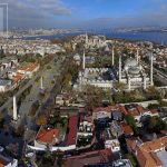
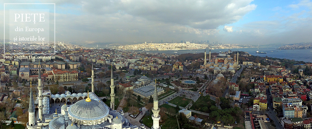
This square bears some of the ambiguity of the meeting point of the Orient and Europe. This is not a single square, but rather two squares brought together and identically named. Between the Hagia Sophia and Sultan Ahmet Camii, known as the Blue Mosque, lies a square with a fountain at its centre, often called Ayasofya Meydani, although the official name is Sultanahmet Meydani. It is a market-garden, built on the spot which held the Augusteion, the Roman forum of Augustus. Paradoxically, the long square between the Blue Mosque and the Museum of Islamic Art keeps the name Sultanahmet Park, although it is less of a park than the neighbouring square. There is no place in the world that brings together so much history. The obelisk of Theodosius the Great is, in fact, Egyptian, and was brought here in 390, from Luxor. Sculpted in Aswan granite, it was built in 1490 B.C. for the Egyptian pharaoh Thutmose III. The serpentine column was brought in 324 to the temple of Apollo at Delphi, where it celebrated the victory of the Greeks against the Persians. Cast from the alloy of the Persian weapons and melted down by the Greeks, it is now 2500 years old. Another obelisk was built in the 10th century by Constantin VII. One must also add the “German fountain” built in 1900 to mark the visit of Kaiser Wilhelm II. Then, there is the Art Nouveau façade, with the Oriental features of the building, which is now houses the rectorship of Marmara University. The Blue Mosque and the Hagia Sophia define a side of the square. On the opposite side, the Museum of Islamic Art is found in the palace of Ibrahim Pasha, the vizier of Suleyman the Magnificent. A marble column marks the kilometre zero of the Eastern Roman Empire, still visible in the north-eastern corner of the square. And that is not all. The square is, in fact, the arena of the Roman hippodrome.
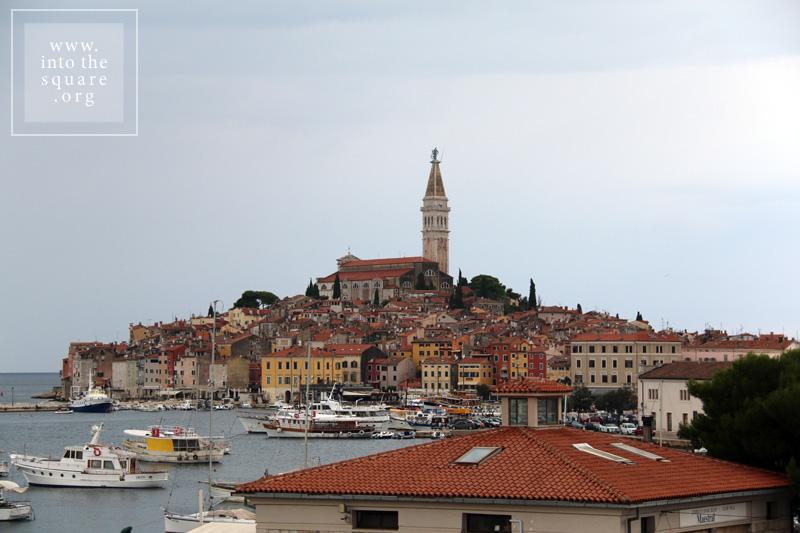
The history of this city is tied to Venice, but Rovinj was built much earlier, at the start of the 8th century, on an island separated from land by a narrow canal. Much later, in 1763, towards the end of Venetian rule, the community silts the isthmus and the city is united with the mainland. Through a classic process of synoecism, a new system of markets takes shape right on the spot of the old canal. They are four in number, and the most important is Trg G. Matteottija. Most of the buildings here are from the 19th century, but they celebrate the past link of the city with Venice, even recreating the lion of San Marco on the city hall’s pediment. The main square of the city remains Trg Sveta Eufemije, found at the highest point on the hill. Unobstructed on three sides, it gazes out to the sea, dominated by the 60 meter campanile of the basilica, with the statue of Saint Euphemia at the top, rotating in the breeze.
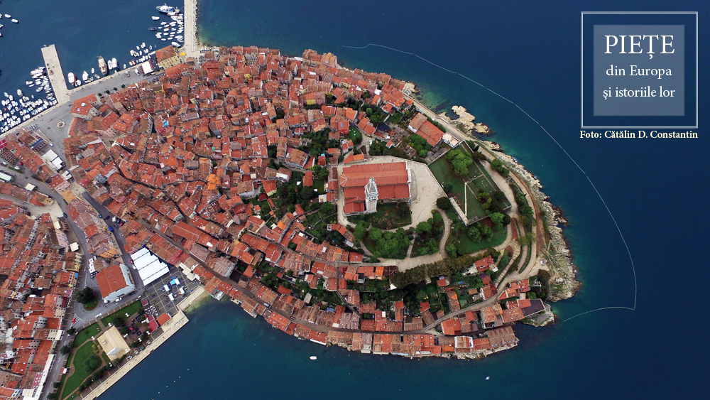
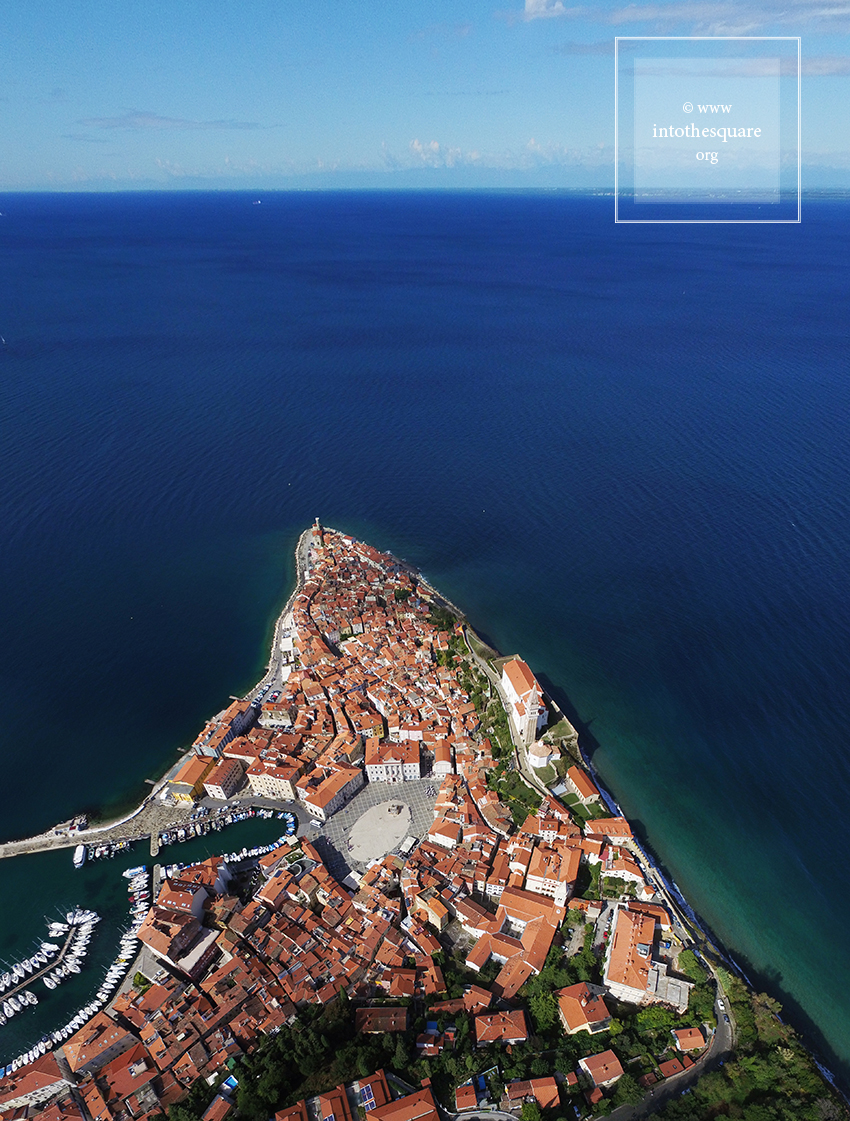
Giuseppe Tartini, author of the well known Il trillo del diavolo, was born in this city, then called Pirano, part of the Republic of Venice. The Piran square bears his name, and the birthplace of the composer can be found on one side of the square. At the time of his birth, however, the place looked completely different. Rather than a square, this area was first a loading dock for fishing boats coming in from the Adriatic, found outside the citadel walls . In time, palaces and beautiful administrative buildings were built closer to the piers. By 1894, the importance of the place grew enough that the authorities decided to silt the gulf and build a true square. Two years later, Tartini’s statue is unveiled, thought of as a focal point, and the square, dominated from the hill by the Saint George church and with a campanile identical to the one in Venice, is a harmonious and lively space, with a proper and accomplished balance of form and proportion.
Prešernov trg was a simple crossroads at the entrance to the medieval city, where, in 1646, a Franciscan monastery was built and remains to this day. In the 19th century, the crossroads was paved and started to resemble an urban square. The end of the same century brought about a radical transformation, as an earthquake in 1895 resulted in the old houses being replaced by Neoclassical and, later, Sezession style buildings. In 1980, the Slovenian architect Edvard Ravnikar created the current circle design of its pavement, which lends a special note to the square: a sun, on a granite background, with rays made of Macedonian Prilep marble. A triple bridge, Tromostovje, across the Ljubljanica, ties the square through Stritarjeva ulica to the old square of the city, found at the foot of the hill where the castle is, next to the cathedral. The city square, Mestni trg, is dominated by a fountain built in 1751. The two squares, although they were not planned together, as each was partly the result of later redevelopments, represent an unexpectedly coherent and suggestive urban whole.
Founded in 1354, in a thick forest, on the spot where two roads crossed next to waterways at the border between Moravia, Bohemia and Austria, Telč (or Teltsch in German), had the misfortune of experiencing a great fire two centuries later. The city was quickly rebuilt following the original plan, but with modifications which took into account the evolution of building styles and techniques. The Gothic castle was remade in the Renaissance style and lofts were built for the houses in the square. The houses received painted façades, which were later replaced in the 18th century with rococo and baroque ones. The medieval Gothic arch on the ground floor remained unchanged. It is continuous, uniting all the houses in the square. Two churches were built and a plague column was dedicated to Saint John Nepomuk, flanked by two fountains. Towards the end of the 18thcentury, time suddenly stopped in Telč, with the end of its age of glory and economic development. The city reached our times without further changes, unaffected by industrialisation and, through some miracle, without socialist blocks. It is straight out of a book of folk tales. The map of the city is practically synonymous with the triangular square. One step outside of it carries you to the yellow canola fields of the Bohemian hills.