

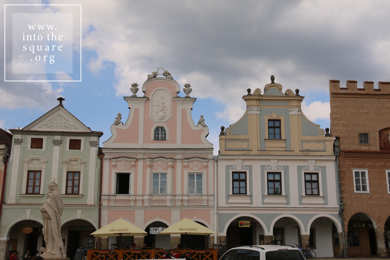
Ιδρύθηκε το 1354, σε ένα πυκνό δάσος, στο σημείο όπου δύο δρόμοι διέσχιζαν δίπλα σε υδάτινες οδούς τα σύνορα μεταξύ Μοραβίας, Βοημίας και Αυστρία. Το Telč (ή το Teltsch στα γερμανικά) είχε την ατυχία να βιώσει μια μεγάλη φωτιά δύο αιώνες αργότερα. Η πόλη ανοικοδομήθηκε γρήγορα σύμφωνα με το αρχικό σχέδιο, αλλά με τροποποιήσεις που έλαβαν υπόψη την εξέλιξη των στυλ. Το γοτθικό κάστρο αναδιαμορφώθηκε στο αναγεννησιακό στυλ και κατασκευάστηκαν σοφίτες για τα σπίτια στην πλατεία. Οι οικίες απέκτησαν ζωγραφισμένες προσόψεις, οι οποίες αργότερα αντικαταστάθηκαν τον 18ο αιώνα με άλλες σε στυλ ροκοκό και μπαρόκ. Η μεσαιωνική γοτθική καμάρα στο ισόγειο παρέμεινε αμετάβλητη και συνεχής, ενώνοντας όλα τα σπίτια στην πλατεία. Δύο εκκλησίες και μια στήλη χτίστηκαν στην περίοδο της πανούκλας αφιερωμένα στον Άγιο Ιωάννη Nepomuk, πλαισιωμένη από δύο βρύσες. Προς τα τέλη του 18ου αιώνα, ο χρόνος σταμάτησε ξαφνικά στο Telč, με το τέλος της εποχής της δόξας και της οικονομικής ανάπτυξης. Η πόλη έφθασε στην εποχή μας χωρίς άλλες αλλαγές, ανεπηρέαστες από την εκβιομηχάνιση και, με κάποιο θαύμα, χωρίς σοσιαλιστικά μπλοκ. Είναι σαν να έχει βγει από ένα βιβλίο λαϊκών παραμυθιών. Ο χάρτης της πόλης είναι σχεδόν συνώνυμος με την τριγωνική πλατεία. Ένα βήμα έξω από αυτό μας μεταφέρει στα κίτρινα πεδία της ελαιοκράμβης των λόφων της Βοημίας.


Masarykovo náměstí from Třeboň, Czech Republic


Třeboň, or Wittingau in German, has one of the best-preserved medieval squares in Bohemia. In fact, only its shape dates from medieval times, since its current form, with its Renaissance and Baroque houses, resulted from the flourishing fish trade of the 14th century. Beginning in the mid-14th century, the natural landscapes around the city were gradually transformed by human intervention. The marshlands gave way to a dense network of over 500 lakes, grouped into 16 aquatic systems, today a paradise returned to the wilderness and populated with rare species of plants and animals. The largest of these lakes is located right near the city and is tied to the Rosenberg family, owners of the medieval burg. Like all historical cities in Bohemia and Moravia, this square contains a plague column; a Renaissance fountain; and a tower building belonging to the City Hall.


Náměstí from Štramberk, Czech Republic


Similar to many other small, out-of-the-way places, this square is simply called “Square,” or Náměstí in Czech. Štramberk is yet another example of a place where the entire town is condensed into its square. Aside from the row of houses that line its perimeter, only two or three additional streets complete the map. Trúba, a cylindrical tower consisting of the remains of a castle about which few things are known, dominates this settlement, perched on a nearby wooded hillside. Everything here reminds one of a fairy tale, from the forests to the castle to the square. A large number of wooden houses from the 18th and 19th centuries also add to the local cultural heritage. The land where Štramberk is located is called Valašsko, from the name of the populace who migrated here in waves, along the Carpathians from Transylvania and, perhaps, from Bukovina. Though the language of the Vlachs was lost along the way, and these people were slavicised, some customs did survive, such as the traditional building techniques that were adapted by local Czech and German craftsmen. The wooden houses clearly bring to mind the wooden Romanian architecture from Transylvania. A number of local settlements had such centres, but the wooden houses have been replaced by stone ones, usually Baroque in style. Štramberk has the greatest number of Vlach-style wooden houses, as they are called here, creating an interesting architectural reservation. Its square is also linked to the preparation of local cakes called “Štramberk ears,” which legally can only be made here. It is said that they have this name because the people of medieval Štramberk thought they resembled the ears of captured Tatar soldiers, during the time of the Tatar raids. 