The history of Aristotelous square began with a fire that destroyed two thirds of the city in 1917. Until that point – due to centuries of Ottoman rule – Thessaloniki was an Oriental city, with no square. Moreover, any attempt to design one had been thwarted by the impossibility of demolishing an area which had been built too densely. However, what cannot be achieved by architects can be accomplished by fire. The project was prepared by Frenchman Ernest Hébrard in 1918, but finalised only in 1950.
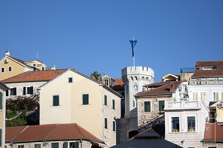
Herceg Novi (Castelnuovo in Italian) is not new as the name claims, but rather quite old, for it was founded in 1382 on the site of a fishing village by the Bosnian King Stephen I, which is also the name of this town’s central square. The Turks conquered the town in 1482 and remained there for two centuries, with a brief Spanish interlude. The town came under Venetian rule in 1687, then passed to Austro-Hungary. After that, Herceg Novi was temporarily ruled by Napoleon, the Russians, and Mussolini, and then became part of Yugoslavia. Its history, though not in its entirety, can be found in its square. It is paradoxical square, for it was built in a typically Italian style, with a splendid Orthodox church in the middle, surrounded by palm trees. Unofficially, the name of the square is Belavista. From there the sea is visible, as well as an Ottoman clock tower, a Spanish fortress, the bell tower of the Catholic church and the lower part of the city.
Náměstí Svornosti is a small, 45 x 60 meter square. Beautiful but unexceptional, grouping a number of houses with Renaissance façades, it has a baroque column and is bounded on one side by the arches of the old City Hall building. The town, called Krumau in German, grew around the splendid castle, whose first historical mention is encountered in a 13th century poem. The castle has always remained the focal point, whilst the square held a secondary role, which accounts for its size, also determined by its location on a bend of the Vltava river. But it too remains a key element in the fairy-tale like atmosphere of the settlement, which has become renowned across the world and, thus, invaded by far too many tourists for such a small town.
This square has an important role in the social and economic life of the Leira community, for it is filled with cafes and terraces, where numerous events are organised. The square’s pavement is considered one of the most beautiful in Portugal. In medieval times, the square held seasonal fairs.
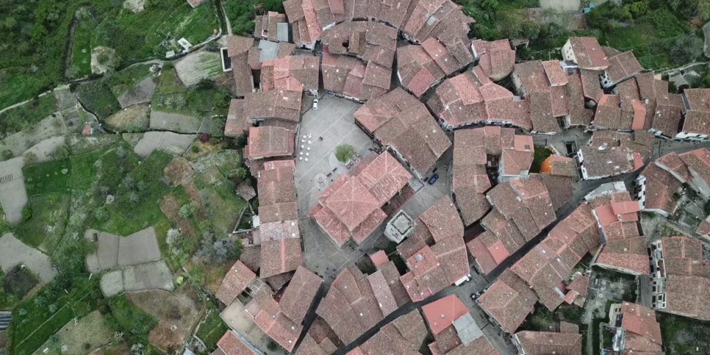
Mogarraz is a small, historic settlement in Sierra de Francia, the mountains near Salamanca. The origins of the settlement stem back to the 11th century, when it was founded by the Gascons. The village is well-known today in Spain due to the hundreds of portraits of locals, drawn on house walls by Florencio Maíllo, a local artist who began this undertaking in the 1960s, as the settlement became increasingly depopulated. Mogarraze is also interesting for its maintenance of a large part of its older architecture, and because its structure is close to the original one, with an eccentric square, and a fairy-tale atmosphere.
This is a square filled with life, bars, shops, taverns, terraces, restaurants. Built between 1821 and 1851 in a neoclassical style and surrounded by identical buildings, with three levels and a colonnade, it is called Plaza Nueva, in contrast to the city’s medieval square, and measures 3400 square meters. The functionalist style of its buildings and the absence of rich decoration reflect the ideas of the Enlightenment, for the square was planned at the end of the 18th century, although its construction began a few decades later. The first architect of the square was Silvestre Pérez. The space gives one the feeling of a giant yet intimate palace salon. Every Sunday, Plaza Nueva hosts a flea market.
A true symbol of Georgian independence, this area was named Freedom Square in 1918, during the First Georgian Republic. The name returns after the collapse of the USSR, proudly defining the country’s current identity, strengthened by the golden statue of Saint George defeating the dragon, which was placed here in 2006. It is interesting to note how the successive names of the square perfectly represent the history of Georgia in the modern age. When the square is built in the beginning of the 19th century, it is called Erevan or Ivan Paskevich Square – named after the general of the Russian Imperial Army, who conquered Erevan, eventually receiving the title of Count of Erevan. In the time of the USSR it was first called Beria Square, then Lenin Square, with a statue of Lenin dominating the centre until 1991.
An interesting look into the dynamics of the urban network of the city: at first, when there was an intersection of trading routes with an inn, rather than a square, this area was located towards the margins of the settlement. The gradual development of the commercial margin of the city eventually becomes a centre, something encountered in many big Western European cities. An especially adventurous historical episode takes place here: in 1907, the square is the scene of a famous bank heist, organised and led by Stalin himself.
This square is among the largest in Europe, and bears the name of King Ottokar II of Bohemia, who in 1256 founded the town, called Budweis in German. The Black Tower, built in the 16th century, and the Cathedral of Saint Nicholas are found in its south-eastern corner. The Baroque City Hall building lies at the opposite corner of the square, whilst its central point is occupied by Samson’s Fountain, featuring elaborate Baroque decorations. Completing the square are 48 houses with coats of arms; a beer factory; and a salt market.
Legend has it that whenever they wanted to build a village, the wandering shepherds of the Pindus chose a place and planted a tree. If the tree – which they passed by at least twice yearly with their herds – grew well, they would build a settlement there, with the tree as its heart. All of the Aromanian settlements in the Pindus have a square and all of them have an ancient tree at their centre. The locals call the square the plateia, platia, mishori or mesohori. These contain all the important buildings in the life of the community. The church, the school, the fountain, the cafes, all of these are found in the square. Or, rather, they define the square. Where they are the square is as well. It is a spatial, architectural definition, but especially a social and anthropological one, for this is the place where all important community events take place. For this reason, before having an architectural definition, the square has an anthropological definition. These are not squares meant to be seen, but squares where things are meant to happen. Their main function is not aesthetic, but social. And what happens, in brief, is the story of the community, which must function as a whole.
This is one of the largest squares in Spain and lies right at the entrance of the medieval town. Its origins are found in the 11thcentury, when the space was used for the great traditional holidays. The buildings are from different eras, with all of them having a 16th century ground floor colonnade. On the northwestern side, the Bujaco Tower is an eye-catching building, now a symbol of city. It was built during the Arab rule, on top of Roman foundations. The origins of its name may come from the local word for straw dolls, bujacos.
The story of European squares is tied through a continuous historical thread to Greek antiquity where the plateia and then the agora appear. The urban square is specific to Europe, for such a continuity is not present in other cultures, even if they also posses squares, some very large in size. It was Europe that invented the square and developed it as an architectural form, in order to export it across the world, mainly during the colonial period.
Poreč, Croatia
At first a simple widening of the main road in a Greek polis, the square gains, with time, community and religious functions and is also beautified. From the Greeks, the square is adopted by Roman architects, where the forum is essential in the planning of space. After the fall of the Roman Empire, urban life returns to Europe only around the year 900, when many medieval burgs grow on top of old Roman settlements, maintaining their plans, with the forum becoming a central square, as one finds in Zadar or Poreč, on the Dalmatian coast.
Any medieval town, when photographed by a flying drone, allows one to see the fundamental opposition between margin and centre, for medieval towns are always surrounded by walls. Some, such as Óbidos, in Portugal, have kept these fortifications intact to this day. The square is a wide space, standing in volumetric opposition to city streets, always narrow and winding. Almost always, the medieval square has a cathedral and a fountain. For smaller towns, the role of the fountain is also functional. For larger ones, its role is purely aesthetical, for the presence of the fountain has to do with tradition and ritual.
Óbidos, Portugal
The existence of the walls has had several important consequences for the cities of Western Europe. First of all, limited space meant that, for centuries, the population size remained constant within the walls. When the population size grows, it is preferable that new cities are built, rather than expanding the fortified centre, which is why the Middle Ages excel at founding settlements. Construction always begins with the centre, the square, its spot is the first to be fixed. A second important consequence of walls: the centre always stays the same. In these communities the square is essentially superimposed on the geometrical centre. It was the most protected space. The last place reached by the enemy. Then, there are only a few gates allowing access into the cities. Automatically, all entry roads lead to the central square. Seen from the air, it becomes clear that the square is the centre of the medieval town. The walls visually mark, as clearly as possible, the opposition of the centre to the periphery. Thus, another evolutionary consequence: when, at the dawn of modernity, the walls are torn down, the settlements tend to develop concentrically, rather than linearly, adding more space to a pre-existing structure, a structure still visible in many European cities today.
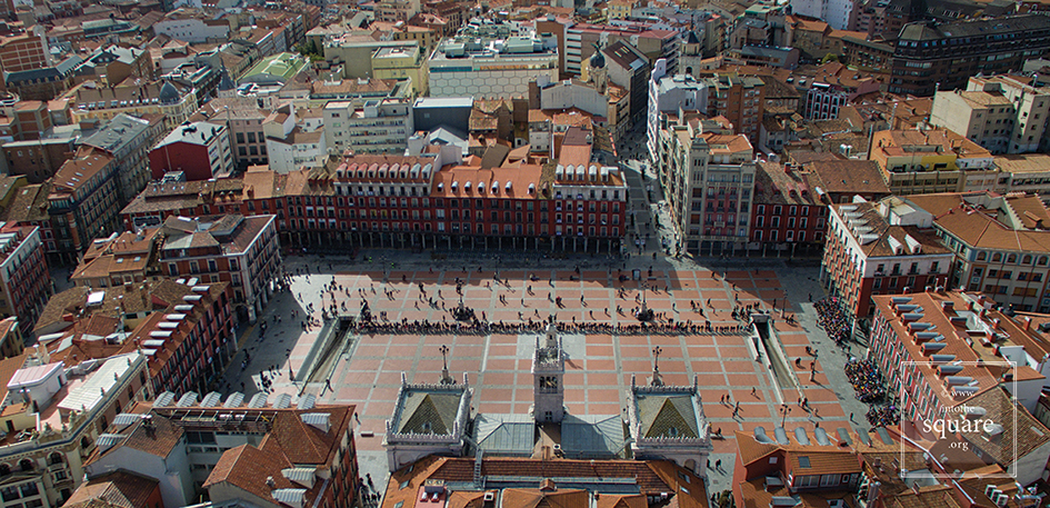
Valladolid, Spain
During the Renaissance, Europe inherits medieval cities. She loves these no longer and wishes them to be completely different: within certain limits, Europe imagines a different kind of urban worlds. The age is, however, not famed for the founding of real cities, but of fictitious ones. When theory does give way to practice, it is usually as a result of calamities. On the 21st of September 1561, a great fire engulfs the city of Valladolid. The city’s catastrophe is a real blessing for urbanism. In the empty space, the splendid Plaza Mayor is built, until today one the largest in Spain. It is the first regular square in Europe, yet, unfairly, it unfairly remains little known. Its symmetry and plan can be clearly seen from above. The architectural and urban pattern instituted at Valladolid is taken by many other squares, reaching perfection in 1729, through Plaza Mayor in Salamanca, one of the most beautiful squares in the world. The aerial photograph immediately shows that the square’s perimeter is not a square, but a trapezoid. Seen from a normal perspective, the square is perceived by any traveller as having perfectly parallel and even sides: a subtle optical illusion, carefully calculated to deepen the perspective and thus counter the relatively small space available to the architect.
Salamanca, Spain
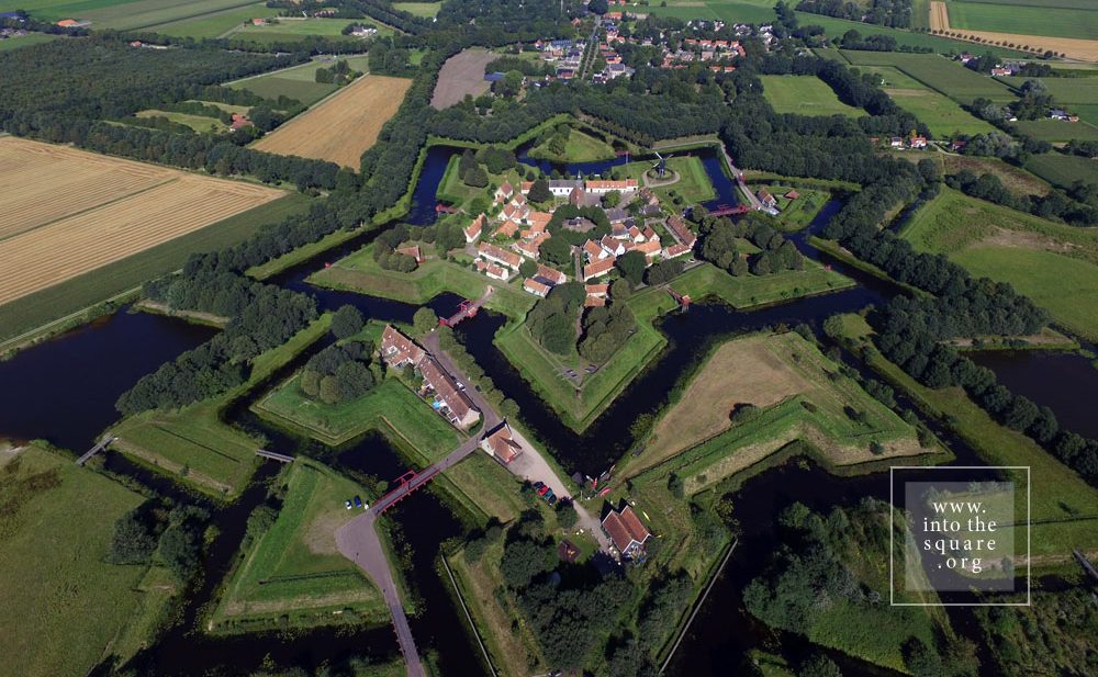
Starting with the 16th century, cities still have fortifications, yet they are planned differently. The mission of city planning increasingly passes from the architect-artist to the engineer. The essential moment of change comes in the 17th century and is associated with Vauban. The type of fortification he proposes means stationing a great number of soldier within massively fortified city walls. Star forts rapidly appear across Europe, from Naarden and Bourtange, in Holland, to Almeida, in Portugal, or Alba Carolina, in Romania. These military settlements have a perfect structure, with straight and aligned streets, always leading to a large square at the centre. Seen from the ground, the perfection of the forts can only be felt, especially since the buildings are often austere. They are, however, by far among the most beautiful European settlements which can be photographed from the air, stars set down upon the earth. Nowhere is the importance of the square as a central space made clearer that in their case.
Naarden, Nederland
After the middle of the 18th century and throughout the 19th century, cities reinvented themselves in a way which reflects the military, technological, but also political changes. The self-governing power of urban communities had steadily dwindled, eventually collapsing before the autocracy of the monarchs. The kings bring soldiers in the cities and the soldiers need straight streets. In order to act quickly, but also in order to properly organise their parades. Thus, the self-governing power of the urban communities gradually drops to nothing. Aristocrats increasingly live in their summer palaces, they wish to be closer to governing centres. They build residences in the city. In time, these turn into their main homes. All of a sudden, many become interested in what the city looks like. The consequence? The planning of cities changes drastically. If ancient medieval settlements have a structure based on the needs of the entire community, cities are modified in order to correspond to the taste of the aristocracy. Essential transformations take place in urban aesthetics. When the streets become straight, the perspective opens, people start seeing further, beyond the first curve. From this to theorising the vista there is but a step. The vista, unknown to classical Antiquity, necessitates a much more complex urban vision: monuments and statues must not only be seen up close. Indeed, they are a landmark and can be found at the end of a long, straight street, which allows the square to be seen from a great distance.
Lisbon, Portugal
What used to be a chance effect now turns into something to be studied. Triumphal archways, commemorative columns, statues are built so as to also be beautiful from a distance. From here to the ceremonial axes that will go through the cities, tying squares together, there is merely a step to be taken. Seen from above, Lisbon unveils at once the transformations undertaken under the leadership of the Marquise of Pombal, after the devastating earthquake of 1 November 1755. Lisbon’s squares represent a real system. Wide, aligned boulevards link the Trade Square to Rosio, Rosio to de Figueira, Martim Moniz and the Restauradores, the Restauradores to Praça do Marquês de Pombal, and all of these have impressive monuments at their centre.
In order for the square to exist, buildings alone do not suffice. Cities are a blend of people and buildings, and the relation between these two terms is not as clear as it would seem on first glance. People create the buildings, and the way in which a community sets its story, history, religion, beliefs, the concrete needs of daily life into a space, has remained mostly unclear to this day. Indeed, countless nuances of this complicated process are elusive, and will most likely never be fully described. A square is its architecture, but, at the same time, it is more than its architecture. Its entire past, chained in an invisible-visible system of links to the symbolic imaginary of the community, makes its presence felt in the existence of the square.
Today this is a village, with 133 houses and fewer than 300 inhabitants. Yet Bourtange was built as a military fort in 1593, during the Dutch Revolt, on the orders of William the Silent. It held this role until 1851, when it officially lost its defensive function and became populated by craftsmen and farmers. Its initial purpose was to guard the road linking Spanish Groningen to Germany. It is one of the most spectacular star-shaped forts in Europe. The pentagonal plan and its network of canals and fortifications respects the original project. The square stands in the geometric middle and follows the pentagonal shape of the buildings placed within the fort. Its perimeter is perfectly defined by 14 lime trees which are over 300 years old. The square holds the most important houses: the captain’s house, the commander’s house, and the house of the school headmaster, for the placement of its buildings was hierarchical. The Protestant church dates from 1869 and, notably, is situated close to the square but not within the square itself.
On the Portuguese side of the border there are even more fortifications than in Spain. Almeida is found in the north of Portugal. It is a star-shaped fort with 12 corners, Vauban style, built in 1641. The Spanish only entered there once in all their history, and then with the help of the French. The square is an irregular quadrilateral and is not positioned quite geometrically, just as the star is not perfect; but its role as a centre is obvious when viewed in relation to the margins of the citadel.
Coimbra is famous for its university, and monumental squares are located in the university area. The city also possesses a small jewel of a square, modest in size but convincing through its balanced proportions and its historical importance. It is Praça 8 de Maio, found in the city centre, in front of the monastery of Santa Cruz, while further on one finds the Câmara Municipal. This small space manages to not be dwarfed by the height and splendour of the Manueline façade of the church where the first two kings of Portugal lie buried. The buildings on the other three sides are just as visible, likewise the central fountain. The contemporary redesigning of the square also contributes to its openness.


 The functionalist style of its buildings and the absence of rich decoration reflect the ideas of the Enlightenment, for the square was planned at the end of the 18th century, although its construction began a few decades later. The first architect of the square was Silvestre Pérez. The space gives one the feeling of a giant yet intimate palace salon. Every Sunday, Plaza Nueva hosts a flea market.