The history of Aristotelous square began with a fire that destroyed two thirds of the city in 1917. Until that point – due to centuries of Ottoman rule – Thessaloniki was an Oriental city, with no square. Moreover, any attempt to design one had been thwarted by the impossibility of demolishing an area which had been built too densely. However, what cannot be achieved by architects can be accomplished by fire. The project was prepared by Frenchman Ernest Hébrard in 1918, but finalised only in 1950.
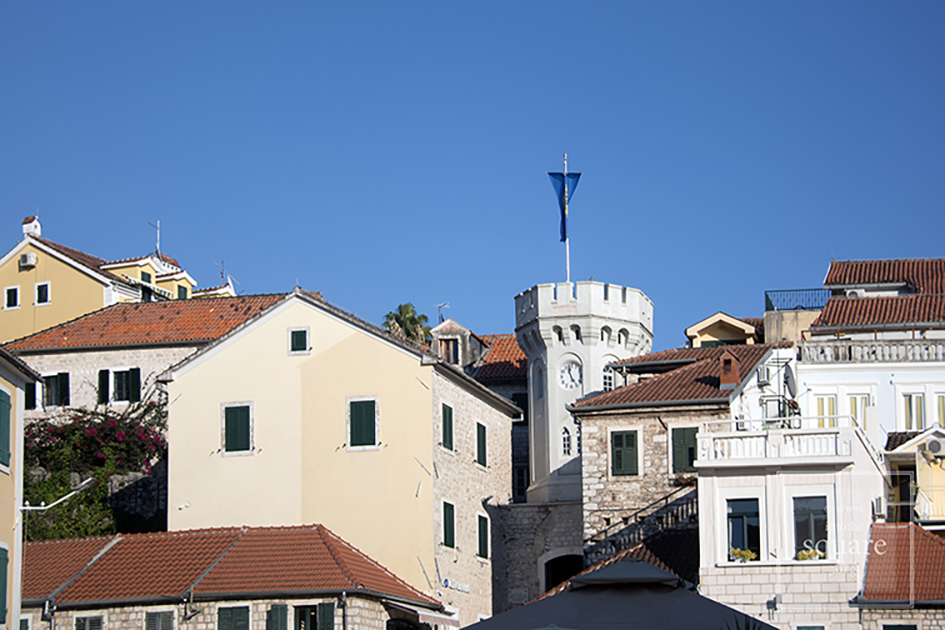
Herceg Novi (Castelnuovo in Italian) is not new as the name claims, but rather quite old, for it was founded in 1382 on the site of a fishing village by the Bosnian King Stephen I, which is also the name of this town’s central square. The Turks conquered the town in 1482 and remained there for two centuries, with a brief Spanish interlude. The town came under Venetian rule in 1687, then passed to Austro-Hungary. After that, Herceg Novi was temporarily ruled by Napoleon, the Russians, and Mussolini, and then became part of Yugoslavia. Its history, though not in its entirety, can be found in its square. It is paradoxical square, for it was built in a typically Italian style, with a splendid Orthodox church in the middle, surrounded by palm trees. Unofficially, the name of the square is Belavista. From there the sea is visible, as well as an Ottoman clock tower, a Spanish fortress, the bell tower of the Catholic church and the lower part of the city.
Náměstí Svornosti is a small, 45 x 60 meter square. Beautiful but unexceptional, grouping a number of houses with Renaissance façades, it has a baroque column and is bounded on one side by the arches of the old City Hall building. The town, called Krumau in German, grew around the splendid castle, whose first historical mention is encountered in a 13th century poem. The castle has always remained the focal point, whilst the square held a secondary role, which accounts for its size, also determined by its location on a bend of the Vltava river. But it too remains a key element in the fairy-tale like atmosphere of the settlement, which has become renowned across the world and, thus, invaded by far too many tourists for such a small town.
This square has an important role in the social and economic life of the Leira community, for it is filled with cafes and terraces, where numerous events are organised. The square’s pavement is considered one of the most beautiful in Portugal. In medieval times, the square held seasonal fairs.
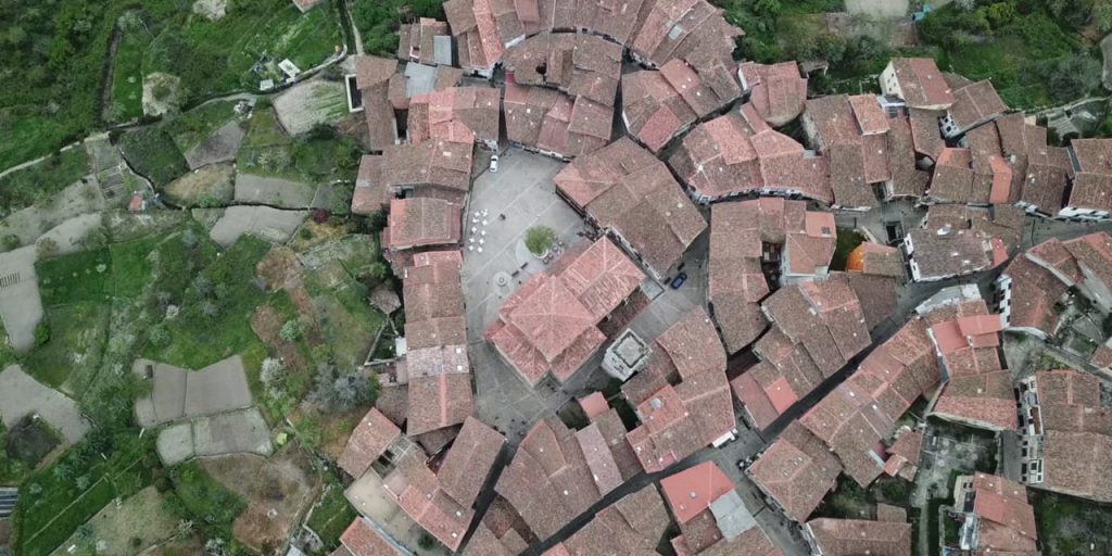
Mogarraz is a small, historic settlement in Sierra de Francia, the mountains near Salamanca. The origins of the settlement stem back to the 11th century, when it was founded by the Gascons. The village is well-known today in Spain due to the hundreds of portraits of locals, drawn on house walls by Florencio Maíllo, a local artist who began this undertaking in the 1960s, as the settlement became increasingly depopulated. Mogarraze is also interesting for its maintenance of a large part of its older architecture, and because its structure is close to the original one, with an eccentric square, and a fairy-tale atmosphere.
This is a square filled with life, bars, shops, taverns, terraces, restaurants. Built between 1821 and 1851 in a neoclassical style and surrounded by identical buildings, with three levels and a colonnade, it is called Plaza Nueva, in contrast to the city’s medieval square, and measures 3400 square meters. The functionalist style of its buildings and the absence of rich decoration reflect the ideas of the Enlightenment, for the square was planned at the end of the 18th century, although its construction began a few decades later. The first architect of the square was Silvestre Pérez. The space gives one the feeling of a giant yet intimate palace salon. Every Sunday, Plaza Nueva hosts a flea market.
A true symbol of Georgian independence, this area was named Freedom Square in 1918, during the First Georgian Republic. The name returns after the collapse of the USSR, proudly defining the country’s current identity, strengthened by the golden statue of Saint George defeating the dragon, which was placed here in 2006. It is interesting to note how the successive names of the square perfectly represent the history of Georgia in the modern age. When the square is built in the beginning of the 19th century, it is called Erevan or Ivan Paskevich Square – named after the general of the Russian Imperial Army, who conquered Erevan, eventually receiving the title of Count of Erevan. In the time of the USSR it was first called Beria Square, then Lenin Square, with a statue of Lenin dominating the centre until 1991.
An interesting look into the dynamics of the urban network of the city: at first, when there was an intersection of trading routes with an inn, rather than a square, this area was located towards the margins of the settlement. The gradual development of the commercial margin of the city eventually becomes a centre, something encountered in many big Western European cities. An especially adventurous historical episode takes place here: in 1907, the square is the scene of a famous bank heist, organised and led by Stalin himself.
This square is among the largest in Europe, and bears the name of King Ottokar II of Bohemia, who in 1256 founded the town, called Budweis in German. The Black Tower, built in the 16th century, and the Cathedral of Saint Nicholas are found in its south-eastern corner. The Baroque City Hall building lies at the opposite corner of the square, whilst its central point is occupied by Samson’s Fountain, featuring elaborate Baroque decorations. Completing the square are 48 houses with coats of arms; a beer factory; and a salt market.
Legend has it that whenever they wanted to build a village, the wandering shepherds of the Pindus chose a place and planted a tree. If the tree – which they passed by at least twice yearly with their herds – grew well, they would build a settlement there, with the tree as its heart. All of the Aromanian settlements in the Pindus have a square and all of them have an ancient tree at their centre. The locals call the square the plateia, platia, mishori or mesohori. These contain all the important buildings in the life of the community. The church, the school, the fountain, the cafes, all of these are found in the square. Or, rather, they define the square. Where they are the square is as well. It is a spatial, architectural definition, but especially a social and anthropological one, for this is the place where all important community events take place. For this reason, before having an architectural definition, the square has an anthropological definition. These are not squares meant to be seen, but squares where things are meant to happen. Their main function is not aesthetic, but social. And what happens, in brief, is the story of the community, which must function as a whole.
This is one of the largest squares in Spain and lies right at the entrance of the medieval town. Its origins are found in the 11thcentury, when the space was used for the great traditional holidays. The buildings are from different eras, with all of them having a 16th century ground floor colonnade. On the northwestern side, the Bujaco Tower is an eye-catching building, now a symbol of city. It was built during the Arab rule, on top of Roman foundations. The origins of its name may come from the local word for straw dolls, bujacos.
Per le città europee la piazza è il luogo più significativo. È lì che convergono le vie più importanti e che si trovano gli edifici e le statue più rappresentative. La piazza di una città europea è un riassunto: storico, architettonico, culturale, sociale. Nella piazza di una città si rivelano spesso simultaneamente tutti gli strati della vita umana, a livello individuale e sociale. Da questo punto di vista, la piazza è uno spazio privilegiato. Un palinsesto che parla, se lo si sa interpretare, delle varie epoche della storia e della vita di quell’insediamento.
La storia delle piazze europee è legata con un filo storico continuo all’Antichità greca, dove appare prima la plateia, poi l’agora. La piazza urbana è specifica per l’Europa, le altre culture non ne possiedono una così lunga continuità, sebbene le piazze esistano pure lì, alcune pure molto vaste. L’Europa ha inventato la piazza, l’ha sviluppata come forma architettonica, per esportarla poi nel resto del mondo, soprattutto nel periodo coloniale.
Πορεκ, Κροατία
Mentre inizialmente si presentava come un mero ampliamento della via principale delle polis greche, col tempo la piazza acquista compiti comunitari e religiosi e comincia ad essere abbellita. Dai greci passa agli architetti romani, che rendono il foro essenziale nel pensare lo spazio. Dopo la caduta dell’Impero romano, la vita urbana ritorna in Europa appena intorno all’anno 900, quando molti dei borghi medievali si sviluppano sugli insediamenti romani, conservando la loro planimetria e struttura stradale, dove al posto del foro subentra la piazza centrale, come avviene a Zdar o Poreč sulla costiera dalmata.Se fotografata dal drone, qualsiasi città medievale rivela la fondamentale opposizione tra il margine e il centro, perché le città medievali sono sempre circondate dalle mura. Alcune, come Óbidos in Portogallo, conservano intatte al giorno d’oggi queste fortificazioni. La piazza è uno spazio ampio, che si oppone come volumetria alle strade sempre strette e tortuose delle città. È quasi d’obbligo che nella piazza centrale si trovino la cattedrale e una fontana. Nel caso delle città piccole, la fontana ha anche un ruolo funzionale. Nel caso di quelle grandi, il ruolo è uno meramente estetico: la presenza della fontana è un riflesso della tradizione, del costume.
Όμπιδος, Πορτογαλία
L’esistenza delle mura ha generato delle conseguenze significative per le città di tutta l’Europa occidentale. Prima di tutto, lo spazio limitato ha fatto sì che, per secoli, la popolazione rimanesse numericamente costante all’interno delle mura. Quando la popolazione cresce, è preferibile fondare un nuovo insediamento invece di allargare la cinta muraria. La costruzione inizia sempre dal centro, dalla piazza, quello è il posto che viene stabilito per primo. Una seconda conseguenza importante dell’esistenza delle mura: il centro rimane sempre lo stesso. In questa comunità, la piazza si sovrappone di solito al centro geometrico, che era lo spazio più protetto. Là il nemico arriva per ultimo. Poi, l’accesso in città si fa attraverso alcune porte e, per forza, tutte le strade portano fino alla piazza centrale. La prospettiva aerea mostra come la piazza sia il punto di focalizzazione della città medievale. Le mura segnano nel modo più ovvio il rapporto di opposizione del centro con la periferia. Da qui deriva nel tempo un’altra conseguenza: quando, agli inizi della modernità, le mura vengono abbattute, queste città tendono a svilupparsi non in maniera lineare, bensì concentrica, aggiungendo delle fasce successive ad una struttura preesistente, ancora visibile, d’altronde, in molte delle città europee odierne.
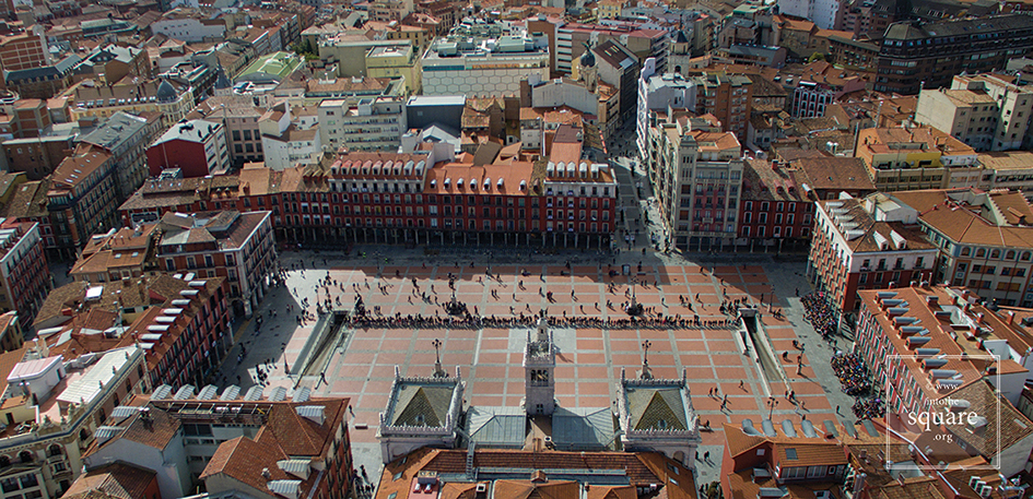
Βαγιαδολίδ, Ισπανία
Nel Rinascimento, l’Europa riceve in eredità le città medievali, alle quali non è più affezionata e che vuole cambiare: nell’ambito di certi limiti costruiti, l’Europa immagina diversi mondi urbani. Questo periodo, tuttavia, non resta nella storia per la costituzione di città reali, quanto per quella di città fittizie. Quando tuttavia la storia pasa dalla teoria alla pratica, ciò avviene piuttosto in seguito a delle calamità. Il 21 settembre 1561, un grande incendio colpisce la città di Valladolid. Quello che per la città è un disastro, è per l’urbanistica una grande opportunità. Nello spazio rimasto vuoto viene costruita la stupenda Plaza Mayor, che resta tutt’ora una delle più grandi di tutta la Spagna. È la prima piazza regolare dell’Europa, oggi ingiustamente misconosciuta come tale. La sua pianta simmetrica si nota benissimo dall’alto. Il modello architettonico e urbanistico istituito a Valladolid viene in seguito ripreso da varie altre piazze e tocca la perfezione nel 1729 con la Plaza Mayor di Salamanca, una delle più belle del mondo. Sempre e solo dall’alto si nota subito che il suo perimetro non è quadrato, ma trapezoidale. All’altezza dello sguardo, chiunque percepisce la piazza con i lati perfettamente paralleli e uguali: una sottile illusione ottica, attentamente calcolata per aumentare la prospettiva e aumentare lo spazio relativamente piccolo che l’architetto ebbe a disposizione.
Σαλαμάνκα, Ισπανία
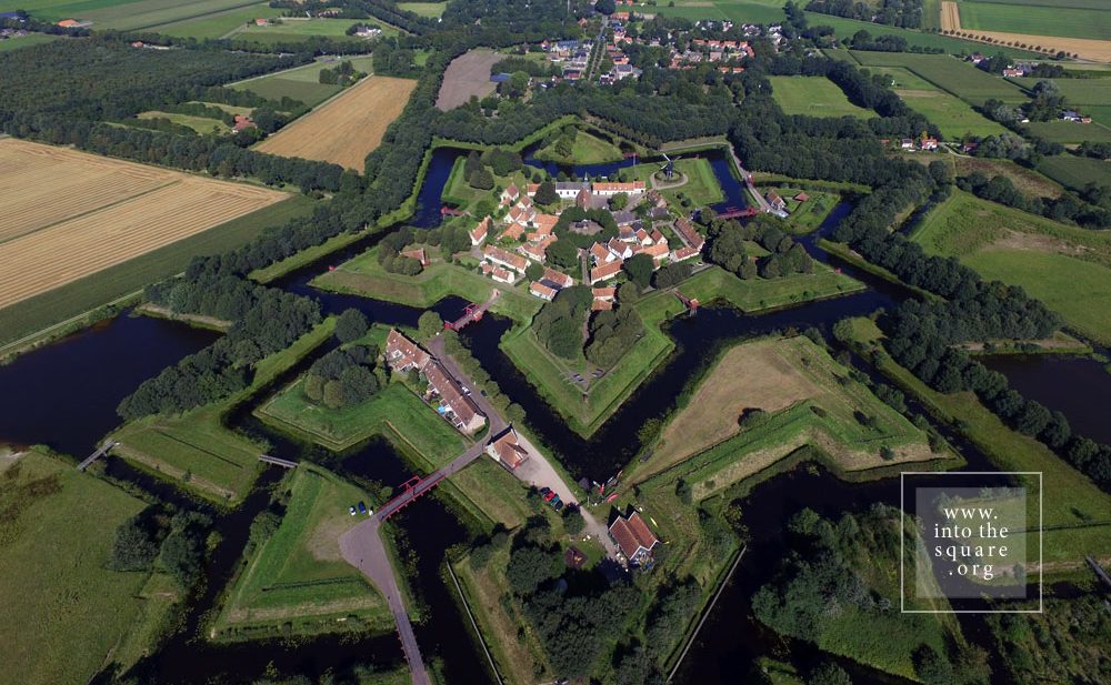
A cominciare dal Cinquecento, le città continuano ad avere le mura di cinta, ma queste vengono pensate diversamente. Sempre di più, il compito di progettare il disegno della città passa dall’artista architetto all’ingegnere. Il momento fondamentale di questo cambiamento viene segnato nel Seicento e collegato al nome di Vauban. Il tipo di fortificazioni che lui propone ha come scopo di far stanziare all’interno della cinta muraria fortificata un grande numero di soldati. I forti a forma di stella si diffondono rapidamente in Europa, da Naarden e Bourtange in Olranda, fino ad Alameida in Portogallo o Alba Carolina in Romania. Queste città militari hanno una struttura perfetta, con vie rette che portano per forza verso una piazza larga, collocata al centro. A livello dello sguardo normale la perfezione dei forti si lascia semmai intuire, anche perché gli edifici sono spesso austeri. Ciò nonostante sono di gran lunga i più belli insediamenti del continente se fotografati dall’alto, come altrettante stelle adagiate per terra. Mai come in questi casi risulta così evidente l’importanza della piazza come spazio centrale.
Νάαρντεν, Ολλανδία
A partire dalla metà del Settecento e lungo l’Ottocento, le città si reinventano in un modo che riflette i cambiamenti militari, tecnologici e politici. L’autorità delle città-stato era già sminuita da un bel po’ di tempo, fino a scomparire completamente di fronte all’autocrazia dei monarchi. Questi aprono l’accesso in città dei soldati, i quali hanno bisogno di vie rette: per un’azione veloce, ma anche per presentare le loro parate. La nobiltà comincia ad abbandonare le residenze fuori città, vuole stare più vicina ai centri del governo e si fa costruire dei palazzi in città. Col tempo questi ne diventano la residenza di base. Indi, molti dei nobili cominciano ad essere interessati a come si presenta la città, sicché i piani di queste cambiano radicalmente. Cambia inevitabilmente il senso delle piazze e il loro rapporto con il resto dello spazio. Laddove gli insediamenti medievali avevano una struttura basata sui bisogni dell’intera comunità, ora le città si modificano per corrispondere al gusto degli aristocratici. Nell’ambito dell’estetica urbana avvengono trasformazioni essenziali. Quando le strade diventano rette, la prospettiva si apre, la gente comincia a vedere a distanza, al di là del primo angolo della strada. Da qui fino al concetto di vista manca solo un passo. La vista, sconosciuta all’Antichità classica, suppone un concetto urbanistico molto più complesso: i monumenti e le statue non vanno viste soltanto da vicino, esse rappresentano un punto di riferimento quando si trovano alla fine di una via lunga e retta che permette all’occhio di penetrare nella piazza anche da lontano. Quello che prima era un effetto scenografico casuale, ora diventa un argomento di studio. Gli archi trionfali, le colonne commemorative, le statue sono costruite e collocate in modo da essere belle anche da lontano. Da qui alle arterie che attraverseranno le città come altrettanti corridoi celebrativi manca solo un passo. Se guardata dall’alto, Lisbona rivela le trasformazioni coordinate dal marchese di Pombal, dopo il devastante terremoto del 1° novembre 1755. Le piazze della città rappresentano un vero e proprio sistema: larghi viali retti collegano la Piazza del Commercio a Rosio, Rosio a Figueira, Martim Moniz a Restauradores, Restauradores a Praça do Marquês de Pombal, e in mezzo a ciascuna di queste troneggia un monumento significativo.
Λισαβόνα, Πορτογαλία
Non bastano gli edifici per far esistere una piazza. Le città sono un amalgama di persone e di edifici e il rapporto fra i due elementi non è tanto chiaro quanto possa sembrare alla prima vista. Le persone costruiscono gli edifici e il modo in cui una comunità sviluppa nello spazio la propria storia, religione, fede di qualsiasi tipo, i bisogni concreti della vita quotidiana non è, ad oggi, molto chiaro: tante sono le sfumature di questo complesso processo che ci sfuggono e forse mai si lasceranno descrivere fino in fondo. Una piazza ha la sua propria architettura ma, allo stesso tempo, rappresenta più della sua architettura. L’intero passato, concatenato in un sistema di rapporti visibile-invisibile con l’immaginario simbolico della collettività, si fa notare nell’esistenza della piazza.
Today this is a village, with 133 houses and fewer than 300 inhabitants. Yet Bourtange was built as a military fort in 1593, during the Dutch Revolt, on the orders of William the Silent. It held this role until 1851, when it officially lost its defensive function and became populated by craftsmen and farmers. Its initial purpose was to guard the road linking Spanish Groningen to Germany. It is one of the most spectacular star-shaped forts in Europe. The pentagonal plan and its network of canals and fortifications respects the original project. The square stands in the geometric middle and follows the pentagonal shape of the buildings placed within the fort. Its perimeter is perfectly defined by 14 lime trees which are over 300 years old. The square holds the most important houses: the captain’s house, the commander’s house, and the house of the school headmaster, for the placement of its buildings was hierarchical. The Protestant church dates from 1869 and, notably, is situated close to the square but not within the square itself.
On the Portuguese side of the border there are even more fortifications than in Spain. Almeida is found in the north of Portugal. It is a star-shaped fort with 12 corners, Vauban style, built in 1641. The Spanish only entered there once in all their history, and then with the help of the French. The square is an irregular quadrilateral and is not positioned quite geometrically, just as the star is not perfect; but its role as a centre is obvious when viewed in relation to the margins of the citadel.
Coimbra is famous for its university, and monumental squares are located in the university area. The city also possesses a small jewel of a square, modest in size but convincing through its balanced proportions and its historical importance. It is Praça 8 de Maio, found in the city centre, in front of the monastery of Santa Cruz, while further on one finds the Câmara Municipal. This small space manages to not be dwarfed by the height and splendour of the Manueline façade of the church where the first two kings of Portugal lie buried. The buildings on the other three sides are just as visible, likewise the central fountain. The contemporary redesigning of the square also contributes to its openness.


 The functionalist style of its buildings and the absence of rich decoration reflect the ideas of the Enlightenment, for the square was planned at the end of the 18th century, although its construction began a few decades later. The first architect of the square was Silvestre Pérez. The space gives one the feeling of a giant yet intimate palace salon. Every Sunday, Plaza Nueva hosts a flea market.