Plaza Mayor from Cáceres, Spain

This is one of the largest squares in Spain and lies right at the entrance of the medieval town. Its origins are found in the 11thcentury, when the space was used for the great traditional holidays. The buildings are from different eras, with all of them having a 16th century ground floor colonnade. On the northwestern side, the Bujaco Tower is an eye-catching building, now a symbol of city. It was built during the Arab rule, on top of Roman foundations. The origins of its name may come from the local word for straw dolls, bujacos.

Praças da Europae e as suas histórias

A história das praças europeias está ligada por um fio histórico contínuo à antiguidade grega, onde aparece a plateia e depois a ágora. A praça urbana é específica da Europa, porque uma continuidade tão longa não está presente em outras culturas, mesmo que nessas também haja praças, algumas mesmo muito grandes. A Europa inventou a praça, desenvolveu-a como forma arquitetónica, para depois exportá-la para todo o mundo, principalmente durante o período colonial.

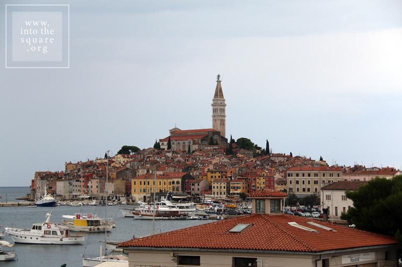
Enquanto nos seus primórdios a praça é um simples alargamento da estrada principal da polis grega, com o tempo, ela adquire funções comunitárias e religiosas e começa a ser embelezada. Dos gregos, a praça é assumida pelos arquitetos romanos, onde o fórum é fundamental na conceção do espaço. Após a queda do Império Romano, a vida urbana recupera na Europa apenas por volta do ano 900, quando muitos dos burgos medievais se desenvolvem por cima dos antigos assentamentos romanos, mantendo o seu plano e esquema de ruas, com o fórum transformado em praça central, tal como acontece em Zadar ou Porec, na costa dálmata.

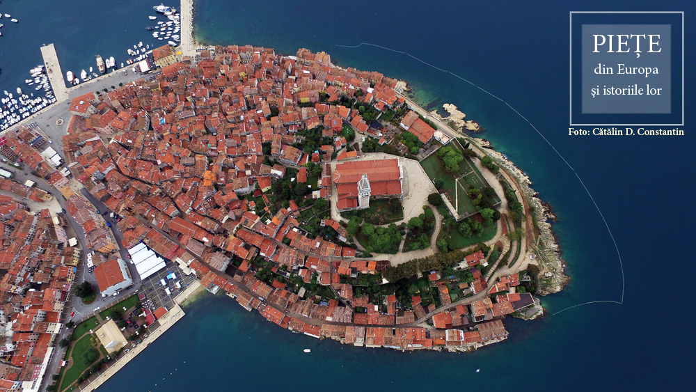
Qualquer cidade medieval, fotografada por um drone, permite-nos ver a oposição fundamental entre a margem e o centro, porque as cidades medievais estão sempre rodeadas por muralhas. Algumas, como Óbidos, em Portugal, ainda mantêm essas fortificações intactas. A praça é um espaço amplo, opondo-se volumetricamente às sempre estreitas e sinuosas ruas das cidades. Quase obrigatoriamente, na praça medieval há uma catedral e uma fonte. Para as pequenas cidades, o papel da fonte também é funcional. Para as grandes cidades, o papel é puramente estético, a presença da fonte na praça estando ligada à tradição e ao ritual.

A existência das muralhas teve algumas consequências importantes para as cidades de toda a Europa Ocidental. Em primeiro lugar, o espaço limitado fez com que, durante séculos, a população fosse numericamente constante dentro das muralhas. Quando a população cresce, é preferível estabelecer novas cidades, em detrimento da expansão do recinto fortificado, e é por isso que a Idade Média é notável na formação de assentamentos. A construção começa sempre com o centro, com a praça, sendo o seu lugar fixado antes de mais nada. Uma segunda consequência importante da existência das muralhas: o centro permanece sempre o mesmo. Nessas comunidades, a praça está, em princípio, sobreposta ao centro geométrico. Era o espaço mais protegido e o sítio em que o inimigo chegava por último. Além disso, a entrada nas cidades é feita apenas por alguns portões. Automaticamente, todos os caminhos de entrada levam à praça central. A perspetiva aérea mostra que a praça é o ponto focal da cidade medieval. As muralhas marcam visualmente, o mais claramente possível, a oposição entre o centro e a periferia. Daí, outra consequência ao longo da evolução: quando, no alvorecer da modernidade, as muralhas são demolidas, essas cidades tendem a desenvolver-se não linearmente, mas concentricamente, adicionando uma sequência de terreno a uma estrutura já existente, estrutura ainda visível em muitas cidades europeias de hoje.

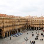
Na Renascença, a Europa herda as cidades medievais, que já não ama e as quer completamente diferentes: dentro de limites construídos, a Europa imagina outro tipo de mundos urbanos. Contudo, a época não é conhecida pela fundação de cidades verdadeiras, mas antes de cidades fictícias. No entanto, quando a teoria se transforma em prática, acontece mais como resultado de certas calamidades. A 21 de setembro de 1561, um grande incêndio alastrou a cidade de Valladolid. O infortúnio sofrido pela cidade é, para o urbanismo, uma verdadeira bênção. No lugar do espaço vazio é construída a esplêndida Plaza Mayor, até hoje uma das maiores praças de Espanha. É a primeira praça regular da Europa, hoje, injustamente, tão pouco conhecida. A sua simetria e o plano vêm-se muito bem de cima. O padrão arquitetónico e urbano estabelecido em Valladolid é adotado por muitas outras praças, atingindo a perfeição em 1729, com a Plaza Mayor de Salamanca, uma das praças mais bonitas do mundo. Só pela fotografia aérea podemos ver imediatamente que o perímetro da praça não é um quadrado, mas um trapézio. Ao nível dos olhos, a praça é percebida por qualquer passante, sem exceção, como tendo lados perfeitamente paralelos e iguais: uma subtil ilusão de ótica, cuidadosamente calculada para aprofundar a perspetiva e compensar o espaço relativamente pequeno que o arquiteto teve à disposição.

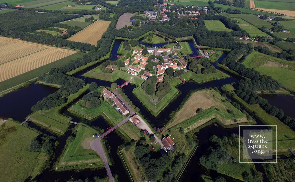
A partir do século XVI, ainda que continuem a ter fortificações, as cidades são pensadas de forma diferente. A missão de desenhar planos urbanos passa cada vez mais das mãos do artista/arquiteto para as mãos do engenheiro. O momento essencial de mudança dá-se no século XVII e está ligado ao nome de Vauban. O tipo de fortificação proposto por ele prevê o posicionamento de um grande número de soldados dentro das maciças muralhas da cidade. Os fortes em forma de estrela rapidamente se espalharam pela Europa, de Naarden e Bourtange, na Holanda, a Almeida em Portugal, ou Alba Carolina na Roménia. Essas cidades militares têm uma estrutura perfeita, com ruas retas e alinhadas, levando, obrigatoriamente, a uma grande praça, no centro. Do nível do solo, a perfeição dos fortes apenas pode ser intuída, especialmente porque os edifícios são muitas vezes austeros. No entanto, são de longe os mais belos assentamentos do continente que podem ser hoje fotografados do alto do céu, umas estrelas colocadas na Terra. Mais do que nunca, no caso dos fortes fica bem clara a importância da praça como espaço central.

Depois de meados do século XVIII e no século XIX, as cidades reinventam-se de tal maneira, que refletem as mudanças militares, tecnológicas, mas também políticas. O poder autónomo das comunidades urbanas enfraquece gradualmente, até o ponto de diminuir totalmente, em favor da autocracia dos monarcas. Os monarcas trazem os soldados para a cidade e os soldados precisam de ruas retas. Para agir rapidamente, mas também para executar lindamente os seus desfiles. Os aristocratas vivem cada vez menos nos seus palácios no campo, por quererem estar o mais perto possível dos centros políticos. Constroem as suas residências na cidade, que, com o tempo, se tornam nas suas residências principais. De repente, muitos deles ganham interesse pela aparência da cidade. Qual a consequência disso? O plano da cidade muda radicalmente. Inevitavelmente, o papel das praças e a sua relação com o resto do espaço muda também. Se os antigos assentamentos medievais têm uma estrutura baseada nas necessidades de toda a comunidade, as cidades mudam de aspeto para atender ao gosto dos aristocratas. Na área da estética urbana ocorrem transformações essenciais. Quando as ruas ficam retas, a perspetiva abre-se e as pessoas começam a ver mais longe, para além da primeira curva. Daqui para a teorização da vista é apenas um passo. A vista, desconhecida na antiguidade clássica, pressupõe uma visão urbanística muito mais complexa: os monumentos e as estátuas não devem ser vistos apenas de perto, atendendo ao facto de que são um ponto de referência mesmo quando estão no final de uma rua cumprida que, sendo reta, permite que o olhar aviste a praça de uma grande distância. O que antes era um efeito aleatório, agora está a tornar-se um elemento de estudo. Os arcos triunfais, as colunas comemorativas, as estátuas são construídas de modo a serem bonitas mesmo de longe. Daqui aos eixos cerimoniais que irão cruzar as cidades, ligando as praças, é só mais um passo. Lisboa, vista de cima, revela de relance as transformações ocorridas, sob a coordenação do Marquês de Pombal, após o devastador terramoto de 1 de novembro de 1755. As praças de Lisboa são um verdadeiro sistema. Avenidas largas e alinhadas ligam a Praça do Comércio ao Rossio, o Rossio à Figueira, ao Martim Moniz e aos Restauradores, os Restauradores à Praça do Marquês de Pombal, e todas têm no meio monumentos impressionantes.

Marktplein from Bourtange, Netherlands

Today this is a village, with 133 houses and fewer than 300 inhabitants. Yet Bourtange was built as a military fort in 1593, during the Dutch Revolt, on the orders of William the Silent. It held this role until 1851, when it officially lost its defensive function and became populated by craftsmen and farmers. Its initial purpose was to guard the road linking Spanish Groningen to Germany. It is one of the most spectacular star-shaped forts in Europe. The pentagonal plan and its network of canals and fortifications respects the original project. The square stands in the geometric middle and follows the pentagonal shape of the buildings placed within the fort. Its perimeter is perfectly defined by 14 lime trees which are over 300 years old. The square holds the most important houses: the captain’s house, the commander’s house, and the house of the school headmaster, for the placement of its buildings was hierarchical. The Protestant church dates from 1869 and, notably, is situated close to the square but not within the square itself.

Praça de São João from Almeida, Portugal

On the Portuguese side of the border there are even more fortifications than in Spain. Almeida is found in the north of Portugal. It is a star-shaped fort with 12 corners, Vauban style, built in 1641. The Spanish only entered there once in all their history, and then with the help of the French. The square is an irregular quadrilateral and is not positioned quite geometrically, just as the star is not perfect; but its role as a centre is obvious when viewed in relation to the margins of the citadel.


Praça 8 de Maio from Coimbra, Portugal

Coimbra is famous for its university, and monumental squares are located in the university area. The city also possesses a small jewel of a square, modest in size but convincing through its balanced proportions and its historical importance. It is Praça 8 de Maio, found in the city centre, in front of the monastery of Santa Cruz, while further on one finds the Câmara Municipal. This small space manages to not be dwarfed by the height and splendour of the Manueline façade of the church where the first two kings of Portugal lie buried. The buildings on the other three sides are just as visible, likewise the central fountain. The contemporary redesigning of the square also contributes to its openness.

Praça do Municipio from Lisbon, Portugal

At a short distance from the monumental Praça do Comércio stands the municipal square, which hosts three important buildings: the Municipality, the Court of Appeals and the Naval Arsenal. It is a small, quiet square, with different rhythms from the Praça do Comércio, which, following the Rua do Arsenal, stands less than 70 meters ahead. Praça do Municipio is equally part of the urban fabric woven from the city’s reconstruction under the guidance of the Marquise of Pombal. This historical detail is enough to make it clear that they must be understood as counterpoints, that is, as parts of a broader, interconnected system of squares.

Plaza Mayor from Ciudad Rodrigo, Spain

This town took its name from Count Rodrigo González Girón. It was he who, in the mid-12th century, banished the Moors from this region once and for all, and built this town on top of a former Roman castrum, itself built atop a Celtic settlement. Its solid fortifications speak to its position on the border with Portugal. Paradoxically, although it is one of the most well-defended European borders on both sides, this frontier was the most stable in all of Europe’s history and has remained this way for 500 years. The only fighting to take place here was against Napoleon’s armies. Nowhere is the relationship between centre and periphery more marked than in such citadels.

Plaza Mayor from Salamanca, Spain

The construction of this square began in 1729, by order of Phillip V, with the square primarily intended for bull fights. Today, it is seen as one of the most beautiful squares in Spain and in the whole of Europe. The space offers a paradoxical optical illusion. From the ground it appears to be a perfect quadrangle, but when seen from an aerial photo, the shape is irregular. The baroque façades of the building, which surround and define the square’s perimeter, seem perfectly symmetrical at first glance, but in reality, none of them are the same height. Entire books have been written about this square in Salamanca, and, to this day, it is considered the absolute model of Spanish squares.

Piața Sfatului from Brașov, Romania

Already from the 14th century, markets were constantly held in Piața Sfatului in Brașov and produce was exchanged. Back then it was called Marktplatz. The space is dominated by the Casa Sfatului, constructed in 1420. It not only forms the centre of the square, but also offers an interesting chromatic counterpoint, through its light colour, to the nearby Schwarze Kirche, the Black Church, visible from the square.

Praça do Comércio from Lisbon, Portugal

This square owes its existence to the great Lisbon earthquake of 1 November 1755 and the fire that followed. On this spot, abandoned due to natural disasters, a new, well-ordered city was built, as a result of reconstruction efforts coordinated by the Marquise of Pombal, the leader of the royal government.

Praça do Comércio was built on Terreiro de Paço, the site where the court of the Royal Palace had previously been held. This name is still used for the square, with its one side facing the Tejo, the greatest river on the Iberian Peninsula. Measuring 175 by 180 meters, this square is one of the largest on the European continent.

Sultanahmet Meydanı from Istanbul, Turkey

This square bears some of the ambiguity of the meeting point of the Orient and Europe. This is not a single square, but rather two squares brought together and identically named. Between the Hagia Sophia and Sultan Ahmet Camii, known as the Blue Mosque, lies a square with a fountain at its centre, often called Ayasofya Meydani, although the official name is Sultanahmet Meydani. It is a market-garden, built on the spot which held the Augusteion, the Roman forum of Augustus. Paradoxically, the long square between the Blue Mosque and the Museum of Islamic Art keeps the name Sultanahmet Park, although it is less of a park than the neighbouring square. There is no place in the world that brings together so much history. The obelisk of Theodosius the Great is, in fact, Egyptian, and was brought here in 390, from Luxor. Sculpted in Aswan granite, it was built in 1490 B.C. for the Egyptian pharaoh Thutmose III. The serpentine column was brought in 324 to the temple of Apollo at Delphi, where it celebrated the victory of the Greeks against the Persians. Cast from the alloy of the Persian weapons and melted down by the Greeks, it is now 2500 years old. Another obelisk was built in the 10th century by Constantin VII. One must also add the “German fountain” built in 1900 to mark the visit of Kaiser Wilhelm II. Then, there is the Art Nouveau façade, with the Oriental features of the building, which is now houses the rectorship of Marmara University. The Blue Mosque and the Hagia Sophia define a side of the square. On the opposite side, the Museum of Islamic Art is found in the palace of Ibrahim Pasha, the vizier of Suleyman the Magnificent. A marble column marks the kilometre zero of the Eastern Roman Empire, still visible in the north-eastern corner of the square. And that is not all. The square is, in fact, the arena of the Roman hippodrome.

Trg Peristil from Split, Croatia

From a bird’s eye view, the old town of Split resembles a rectangular box into which someone has placed buildings, streets, and markets. Beginning in the Middle Ages, two of the larger markets in this citadel played a key role in the history of the city, Narodni Trg, or Spalato in Italian. The People’s Square, called simply Pjaca by the locals, was first mentioned in the 13thcentury, and has a number of superb Gothic buildings. A bit further on, at the entrance to the citadel, lies Trg Braće Radić, called Voćni Trg by the locals, meaning “fruit market,” in reference to its earlier, colourful identity. Just outside the medieval walls is a third great square, Republic Square. Its more recent architecture reminds one of Venice’s San Marco. It was built in the mid-19th century, in a historicist style, demonstrating that Split, long under Venetian rule, still carries on this tradition. These are beautiful squares, each with its own marked individuality, but the oldest and most interesting of the Split squares by far is Trg Peristril, which is smaller, yet considered by locals to be the historical heart of this area. Its history is special. Originally, this square served as the interior courtyard of a palace built for the Roman emperor Diocletian in 305, across a huge surface measuring 300 square meters. In fact, half of the old city of Split lies within the palace walls, the most well-preserved Roman palace today. After the Romans abandoned it, it remained uninhabited for centuries, until the people of Salona used it when taking refuge from the Slavs, turning this former palace into their settlement. And a settlement it shall remain. John of Ravenna, the first local archbishop, oversaw the transformation of the Diocletian mausoleum into a church. This was the moment when the palace courtyard officially became the Cathedral square, with all of the functions of a medieval square. Changes were made to it, but some features were kept, including its red porphyry columns.

Trg Sveta Eufemije & Trg G. Matteottija from Rovinj, Croatia

The history of this city is tied to Venice, but Rovinj was built much earlier, at the start of the 8th century, on an island separated from land by a narrow canal. Much later, in 1763, towards the end of Venetian rule, the community silts the isthmus and the city is united with the mainland. Through a classic process of synoecism, a new system of markets takes shape right on the spot of the old canal. They are four in number, and the most important is Trg G. Matteottija. Most of the buildings here are from the 19th century, but they celebrate the past link of the city with Venice, even recreating the lion of San Marco on the city hall’s pediment. The main square of the city remains Trg Sveta Eufemije, found at the highest point on the hill. Unobstructed on three sides, it gazes out to the sea, dominated by the 60 meter campanile of the basilica, with the statue of Saint Euphemia at the top, rotating in the breeze.