This is one of the largest squares in Spain and lies right at the entrance of the medieval town. Its origins are found in the 11thcentury, when the space was used for the great traditional holidays. The buildings are from different eras, with all of them having a 16th century ground floor colonnade. On the northwestern side, the Bujaco Tower is an eye-catching building, now a symbol of city. It was built during the Arab rule, on top of Roman foundations. The origins of its name may come from the local word for straw dolls, bujacos.
The story of European squares is tied through a continuous historical thread to Greek antiquity where the plateia and then the agora appear. The urban square is specific to Europe, for such a continuity is not present in other cultures, even if they also posses squares, some very large in size. It was Europe that invented the square and developed it as an architectural form, in order to export it across the world, mainly during the colonial period.
Poreč, Croatia
At first a simple widening of the main road in a Greek polis, the square gains, with time, community and religious functions and is also beautified. From the Greeks, the square is adopted by Roman architects, where the forum is essential in the planning of space. After the fall of the Roman Empire, urban life returns to Europe only around the year 900, when many medieval burgs grow on top of old Roman settlements, maintaining their plans, with the forum becoming a central square, as one finds in Zadar or Poreč, on the Dalmatian coast.
Any medieval town, when photographed by a flying drone, allows one to see the fundamental opposition between margin and centre, for medieval towns are always surrounded by walls. Some, such as Óbidos, in Portugal, have kept these fortifications intact to this day. The square is a wide space, standing in volumetric opposition to city streets, always narrow and winding. Almost always, the medieval square has a cathedral and a fountain. For smaller towns, the role of the fountain is also functional. For larger ones, its role is purely aesthetical, for the presence of the fountain has to do with tradition and ritual.
Óbidos, Portugal
The existence of the walls has had several important consequences for the cities of Western Europe. First of all, limited space meant that, for centuries, the population size remained constant within the walls. When the population size grows, it is preferable that new cities are built, rather than expanding the fortified centre, which is why the Middle Ages excel at founding settlements. Construction always begins with the centre, the square, its spot is the first to be fixed. A second important consequence of walls: the centre always stays the same. In these communities the square is essentially superimposed on the geometrical centre. It was the most protected space. The last place reached by the enemy. Then, there are only a few gates allowing access into the cities. Automatically, all entry roads lead to the central square. Seen from the air, it becomes clear that the square is the centre of the medieval town. The walls visually mark, as clearly as possible, the opposition of the centre to the periphery. Thus, another evolutionary consequence: when, at the dawn of modernity, the walls are torn down, the settlements tend to develop concentrically, rather than linearly, adding more space to a pre-existing structure, a structure still visible in many European cities today.
Valladolid, Spain
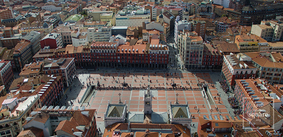
During the Renaissance, Europe inherits medieval cities. She loves these no longer and wishes them to be completely different: within certain limits, Europe imagines a different kind of urban worlds. The age is, however, not famed for the founding of real cities, but of fictitious ones. When theory does give way to practice, it is usually as a result of calamities. On the 21st of September 1561, a great fire engulfs the city of Valladolid. The city’s catastrophe is a real blessing for urbanism. In the empty space, the splendid Plaza Mayor is built, until today one the largest in Spain. It is the first regular square in Europe, yet, unfairly, it unfairly remains little known. Its symmetry and plan can be clearly seen from above. The architectural and urban pattern instituted at Valladolid is taken by many other squares, reaching perfection in 1729, through Plaza Mayor in Salamanca, one of the most beautiful squares in the world. The aerial photograph immediately shows that the square’s perimeter is not a square, but a trapezoid. Seen from a normal perspective, the square is perceived by any traveller as having perfectly parallel and even sides: a subtle optical illusion, carefully calculated to deepen the perspective and thus counter the relatively small space available to the architect.
Salamanca, Spain
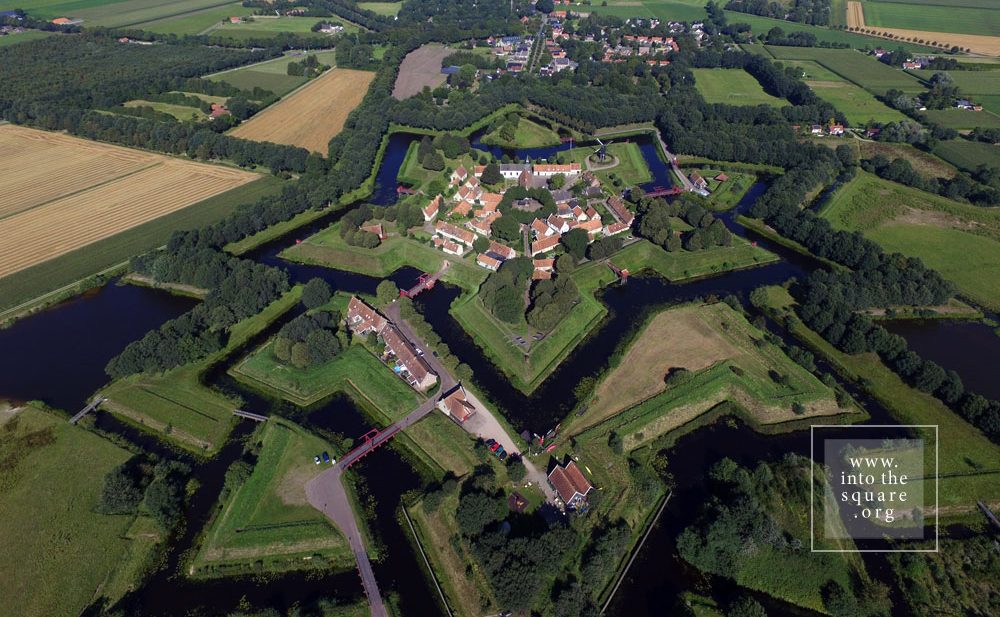
Starting with the 16th century, cities still have fortifications, yet they are planned differently. The mission of city planning increasingly passes from the architect-artist to the engineer. The essential moment of change comes in the 17th century and is associated with Vauban. The type of fortification he proposes means stationing a great number of soldier within massively fortified city walls. Star forts rapidly appear across Europe, from Naarden and Bourtange, in Holland, to Almeida, in Portugal, or Alba Carolina, in Romania. These military settlements have a perfect structure, with straight and aligned streets, always leading to a large square at the centre. Seen from the ground, the perfection of the forts can only be felt, especially since the buildings are often austere. They are, however, by far among the most beautiful European settlements which can be photographed from the air, stars set down upon the earth. Nowhere is the importance of the square as a central space made clearer that in their case.
Naarden, Nederland
After the middle of the 18th century and throughout the 19th century, cities reinvented themselves in a way which reflects the military, technological, but also political changes. The self-governing power of urban communities had steadily dwindled, eventually collapsing before the autocracy of the monarchs. The kings bring soldiers in the cities and the soldiers need straight streets. In order to act quickly, but also in order to properly organise their parades. Thus, the self-governing power of the urban communities gradually drops to nothing. Aristocrats increasingly live in their summer palaces, they wish to be closer to governing centres. They build residences in the city. In time, these turn into their main homes. All of a sudden, many become interested in what the city looks like. The consequence? The planning of cities changes drastically. If ancient medieval settlements have a structure based on the needs of the entire community, cities are modified in order to correspond to the taste of the aristocracy. Essential transformations take place in urban aesthetics. When the streets become straight, the perspective opens, people start seeing further, beyond the first curve. From this to theorising the vista there is but a step. The vista, unknown to classical Antiquity, necessitates a much more complex urban vision: monuments and statues must not only be seen up close. Indeed, they are a landmark and can be found at the end of a long, straight street, which allows the square to be seen from a great distance.
Lisbon, Portugal
What used to be a chance effect now turns into something to be studied. Triumphal archways, commemorative columns, statues are built so as to also be beautiful from a distance. From here to the ceremonial axes that will go through the cities, tying squares together, there is merely a step to be taken. Seen from above, Lisbon unveils at once the transformations undertaken under the leadership of the Marquise of Pombal, after the devastating earthquake of 1 November 1755. Lisbon’s squares represent a real system. Wide, aligned boulevards link the Trade Square to Rosio, Rosio to de Figueira, Martim Moniz and the Restauradores, the Restauradores to Praça do Marquês de Pombal, and all of these have impressive monuments at their centre.
In order for the square to exist, buildings alone do not suffice. Cities are a blend of people and buildings, and the relation between these two terms is not as clear as it would seem on first glance. People create the buildings, and the way in which a community sets its story, history, religion, beliefs, the concrete needs of daily life into a space, has remained mostly unclear to this day. Indeed, countless nuances of this complicated process are elusive, and will most likely never be fully described. A square is its architecture, but, at the same time, it is more than its architecture. Its entire past, chained in an invisible-visible system of links to the symbolic imaginary of the community, makes its presence felt in the existence of the square.
Today this is a village, with 133 houses and fewer than 300 inhabitants. Yet Bourtange was built as a military fort in 1593, during the Dutch Revolt, on the orders of William the Silent. It held this role until 1851, when it officially lost its defensive function and became populated by craftsmen and farmers. Its initial purpose was to guard the road linking Spanish Groningen to Germany. It is one of the most spectacular star-shaped forts in Europe. The pentagonal plan and its network of canals and fortifications respects the original project. The square stands in the geometric middle and follows the pentagonal shape of the buildings placed within the fort. Its perimeter is perfectly defined by 14 lime trees which are over 300 years old. The square holds the most important houses: the captain’s house, the commander’s house, and the house of the school headmaster, for the placement of its buildings was hierarchical. The Protestant church dates from 1869 and, notably, is situated close to the square but not within the square itself.
On the Portuguese side of the border there are even more fortifications than in Spain. Almeida is found in the north of Portugal. It is a star-shaped fort with 12 corners, Vauban style, built in 1641. The Spanish only entered there once in all their history, and then with the help of the French. The square is an irregular quadrilateral and is not positioned quite geometrically, just as the star is not perfect; but its role as a centre is obvious when viewed in relation to the margins of the citadel.
Coimbra is famous for its university, and monumental squares are located in the university area. The city also possesses a small jewel of a square, modest in size but convincing through its balanced proportions and its historical importance. It is Praça 8 de Maio, found in the city centre, in front of the monastery of Santa Cruz, while further on one finds the Câmara Municipal. This small space manages to not be dwarfed by the height and splendour of the Manueline façade of the church where the first two kings of Portugal lie buried. The buildings on the other three sides are just as visible, likewise the central fountain. The contemporary redesigning of the square also contributes to its openness.
At a short distance from the monumental Praça do Comércio stands the municipal square, which hosts three important buildings: the Municipality, the Court of Appeals and the Naval Arsenal. It is a small, quiet square, with different rhythms from the Praça do Comércio, which, following the Rua do Arsenal, stands less than 70 meters ahead. Praça do Municipio is equally part of the urban fabric woven from the city’s reconstruction under the guidance of the Marquise of Pombal. This historical detail is enough to make it clear that they must be understood as counterpoints, that is, as parts of a broader, interconnected system of squares.
This town took its name from Count Rodrigo González Girón. It was he who, in the mid-12th century, banished the Moors from this region once and for all, and built this town on top of a former Roman castrum, itself built atop a Celtic settlement. Its solid fortifications speak to its position on the border with Portugal. Paradoxically, although it is one of the most well-defended European borders on both sides, this frontier was the most stable in all of Europe’s history and has remained this way for 500 years. The only fighting to take place here was against Napoleon’s armies. Nowhere is the relationship between centre and periphery more marked than in such citadels.
The construction of this square began in 1729, by order of Phillip V, with the square primarily intended for bull fights. Today, it is seen as one of the most beautiful squares in Spain and in the whole of Europe. The space offers a paradoxical optical illusion. From the ground it appears to be a perfect quadrangle, but when seen from an aerial photo, the shape is irregular. The baroque façades of the building, which surround and define the square’s perimeter, seem perfectly symmetrical at first glance, but in reality, none of them are the same height. Entire books have been written about this square in Salamanca, and, to this day, it is considered the absolute model of Spanish squares.
Already from the 14th century, markets were constantly held in Piața Sfatului in Brașov and produce was exchanged. Back then it was called Marktplatz. The space is dominated by the Casa Sfatului, constructed in 1420. It not only forms the centre of the square, but also offers an interesting chromatic counterpoint, through its light colour, to the nearby Schwarze Kirche, the Black Church, visible from the square.
This square owes its existence to the great Lisbon earthquake of 1 November 1755 and the fire that followed. On this spot, abandoned due to natural disasters, a new, well-ordered city was built, as a result of reconstruction efforts coordinated by the Marquise of Pombal, the leader of the royal government.
Praça do Comércio was built on Terreiro de Paço, the site where the court of the Royal Palace had previously been held. This name is still used for the square, with its one side facing the Tejo, the greatest river on the Iberian Peninsula. Measuring 175 by 180 meters, this square is one of the largest on the European continent.
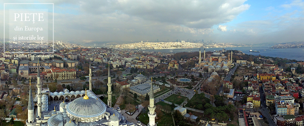
This square bears some of the ambiguity of the meeting point of the Orient and Europe. This is not a single square, but rather two squares brought together and identically named. Between the Hagia Sophia and Sultan Ahmet Camii, known as the Blue Mosque, lies a square with a fountain at its centre, often called Ayasofya Meydani, although the official name is Sultanahmet Meydani. It is a market-garden, built on the spot which held the Augusteion, the Roman forum of Augustus. Paradoxically, the long square between the Blue Mosque and the Museum of Islamic Art keeps the name Sultanahmet Park, although it is less of a park than the neighbouring square. There is no place in the world that brings together so much history. The obelisk of Theodosius the Great is, in fact, Egyptian, and was brought here in 390, from Luxor. Sculpted in Aswan granite, it was built in 1490 B.C. for the Egyptian pharaoh Thutmose III. The serpentine column was brought in 324 to the temple of Apollo at Delphi, where it celebrated the victory of the Greeks against the Persians. Cast from the alloy of the Persian weapons and melted down by the Greeks, it is now 2500 years old. Another obelisk was built in the 10th century by Constantin VII. One must also add the “German fountain” built in 1900 to mark the visit of Kaiser Wilhelm II. Then, there is the Art Nouveau façade, with the Oriental features of the building, which is now houses the rectorship of Marmara University. The Blue Mosque and the Hagia Sophia define a side of the square. On the opposite side, the Museum of Islamic Art is found in the palace of Ibrahim Pasha, the vizier of Suleyman the Magnificent. A marble column marks the kilometre zero of the Eastern Roman Empire, still visible in the north-eastern corner of the square. And that is not all. The square is, in fact, the arena of the Roman hippodrome.
From a bird’s eye view, the old town of Split resembles a rectangular box into which someone has placed buildings, streets, and markets. Beginning in the Middle Ages, two of the larger markets in this citadel played a key role in the history of the city, Narodni Trg, or Spalato in Italian. The People’s Square, called simply Pjaca by the locals, was first mentioned in the 13thcentury, and has a number of superb Gothic buildings. A bit further on, at the entrance to the citadel, lies Trg Braće Radić, called Voćni Trg by the locals, meaning “fruit market,” in reference to its earlier, colourful identity. Just outside the medieval walls is a third great square, Republic Square. Its more recent architecture reminds one of Venice’s San Marco. It was built in the mid-19th century, in a historiciststyle, demonstrating that Split, long under Venetian rule, still carries on this tradition. These are beautiful squares, each with its own marked individuality, but the oldest and most interesting of the Split squares by far is Trg Peristril, which is smaller, yet considered by locals to be the historical heart of this area. Its history is special. Originally, this square served as the interior courtyard of a palace built for the Roman emperor Diocletian in 305, across a huge surface measuring 300 square meters. In fact, half of the old city of Split lies within the palace walls, the most well-preserved Roman palace today. After the Romans abandoned it, it remained uninhabited for centuries, until the people of Salona used it when taking refuge from the Slavs, turning this former palace into their settlement. And a settlement it shall remain. John of Ravenna, the first local archbishop, oversaw the transformation of the Diocletian mausoleum into a church. This was the moment when the palace courtyard officially became the Cathedral square, with all of the functions of a medieval square. Changes were made to it, but some features were kept, including its red porphyry columns.
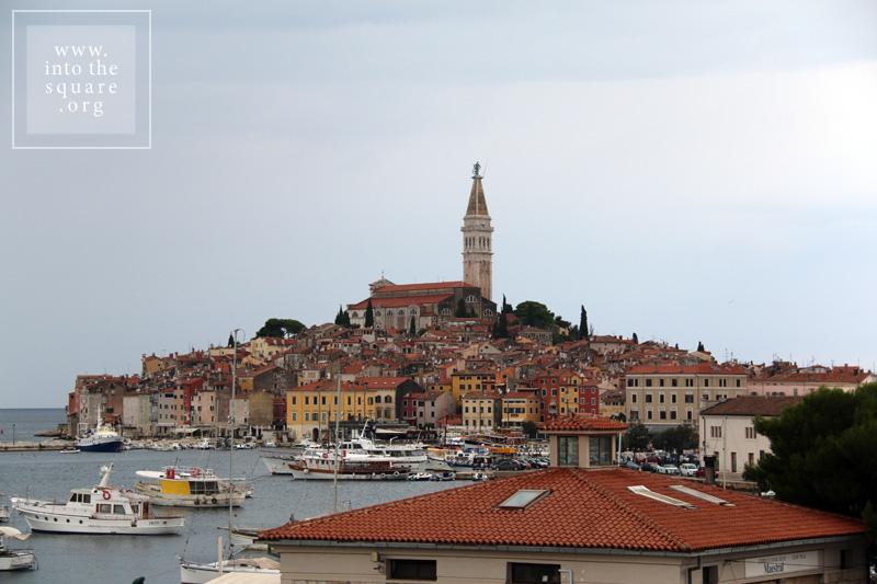
The history of this city is tied to Venice, but Rovinj was built much earlier, at the start of the 8th century, on an island separated from land by a narrow canal. Much later, in 1763, towards the end of Venetian rule, the community silts the isthmus and the city is united with the mainland. Through a classic process of synoecism, a new system of markets takes shape right on the spot of the old canal. They are four in number, and the most important is Trg G. Matteottija. Most of the buildings here are from the 19th century, but they celebrate the past link of the city with Venice, even recreating the lion of San Marco on the city hall’s pediment. The main square of the city remains Trg Sveta Eufemije, found at the highest point on the hill. Unobstructed on three sides, it gazes out to the sea, dominated by the 60 meter campanile of the basilica, with the statue of Saint Euphemia at the top, rotating in the breeze.