This is one of the largest squares in Spain and lies right at the entrance of the medieval town. Its origins are found in the 11thcentury, when the space was used for the great traditional holidays. The buildings are from different eras, with all of them having a 16th century ground floor colonnade. On the northwestern side, the Bujaco Tower is an eye-catching building, now a symbol of city. It was built during the Arab rule, on top of Roman foundations. The origins of its name may come from the local word for straw dolls, bujacos.
W przypadku miast kontynentu europejskiego plac stanowić będzie niezmiennie ich najważniejszy punkt. Tu zbiegają się główne arterie, tu ulokowano reprezentacyjne budowle i pomniki. Plac w mieście europejskim jawi się jako swoiste „podsumowanie” – historyczne, architektoniczne, kulturowe i społeczne. Na placu stają się wyraźne, nierzadko jednocześnie, wszystkie warstwy społecznego życia ludzkiego. Obserwowany z tej perspektywy plac, to przestrzeń uprzywilejowana. Rodzaj palimpsestu, który biegłym w jego języku nieprzerwanie opowiada historię ośrodka miejskiego na przestrzeni zmieniających się epok.
Opowieść, jaką „snują” miasta europejskie, rozwijać się będzie nieprzerwanie od czasów antyku greckiego, kiedy to pojawią się dwa zjawiska: plateia i agora. Na plac miejski patrzeć należy zatem jak na wytwór typowy dla Europy, o ciągłości rozwoju nieznanej innym cywilizacjom, nawet jeśli dopracowały się one w różnych okresach zbliżonych rozwiązań. Jednak niepodważalnym wynalazcą placu będzie Europa, która rozwinie jego formę architektoniczną by w pewnym momencie wyeksportować ją poza stary kontynent, jak to miało miejsce w okresie kolonialnym.
Poreč, Chorwacja
Plac, mający u swego zarania proste poszerzenie głównego traktu, jaki przebiegał przez greckie polis, nabierze z czasem funkcji reprezentacyjnych i religijnych służących danej społeczności i ujęty zostanie w dekoracyjną oprawę. Od Greków jego ideę przejmą Rzymianie, dla których forum będzie kluczowym elementem myślenia przestrzennego. Po upadku Imperium Rzymskiego rewitalizacja życia miejskiego nastąpi w okolicach roku 900, kiedy liczne wczesnośredniowieczne osady rozwijać się będą na dawnych antycznych strukturach, zachowując ich plan, schemat ulic, w końcu forum przeobrażone w główny plac. To scenariusz typowy dla wybrzeża Dalmacji, jak w przypadku miast Zadar i Poreč.
Wykonane dronem fotografie miast średniowiecznych umożliwiają dostrzeżenie fundamentalnej opozycji między centrum a obrzeżem, ponieważ miasta te zamknięte są w pierścień murów obronnych. Nieliczne, jak choćby portugalskie Óbidos, cieszą się do dziś jego pełnym zachowaniem. Plac będzie tu stanowić otwartą przestrzeń, swą objętością przeciwstawiającą się ciasnej siatce wąskich, krętych ulic. Nieodzownymi elementami „umeblowania” placu będą katedra i fontanna. W dużych ośrodkach mieszczącej się na placu fontannie rezerwuje się czysto estetyczną funkcję, związaną z tradycyjnym rytuałem. W przypadku małych miast, przypadnie jej również funkcja użytkowa.
Óbidos, Portugalia
Obecność okalających murów niosła ze sobą niezliczone konsekwencje dla miast całej Europy Zachodniej. W pierwszej kolejności ustalała populację, kiedy przez okres wielu wieków liczba ludności zamieszkującej ujęty w mury obszar pozostawała niezmienna. Gdy populacja rosła, preferowanym rozwiązaniem było zakładanie nowych ośrodków a nie poszerzanie już istniejących. Stąd też średniowiecze, na tle innych epok, przoduje w kategorii zakładania nowych osad. Ich budowę niezmiennie rozpoczynać będzie wyznaczenie miejsca dla placu. Drugą istotną konsekwencją obecności murów będzie niezmienność położenia samego centrum, zaś ulokowanie placu będzie bezpośrednio od niego zależne. Znajdować się on będzie w miejscu najbardziej chronionym, do którego wróg dotrze najpóźniej. Następny element to wjazd do miasta, który umożliwiało kilka zaledwie bram. Automatycznie wszystkie drogi wjazdu do miasta prowadzić będą na plac. Perspektywa z lotu ptaka unaocznia nam, że plac stanowi punkt ogniskowy układu miasta średniowiecznego. Mury wyznaczają w najbardziej przejrzysty sposób relację opozycji pomiędzy centrum a peryferiami. Stąd też, kiedy na progu modernizacji dawne mury ulegną likwidacji, miasta te konsekwentnie rozwijać się będą nie linearnie a koncentrycznie, przez dodanie sekwencji zabudowanego terenu do istniejącej już struktury. To scenariusz jaskrawo czytelny w przypadku licznych europejskich miast.
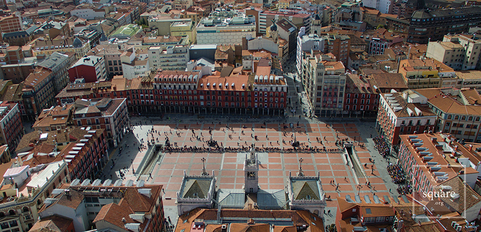
Valladolid, Hiszpania
Okres renesansu otrzymuje w spadku miasta średniowieczne. Odrzuca je i snuje wizje nowych, ulokowanych w zdefiniowanych ramach ośrodków miejskich. Jednak odrodzenie daje się poznać szczególnie jako epoka, która nad lokację nowych ośrodków, przedkłada kreację wyimaginowanych, utopijnych. Teoria przeradza się w praktykę jako konsekwencja katastrof i klęsk żywiołowych. W roku 1561 potężny pożar trawi w całości centrum miasta Valladolid. Z perspektywy ówczesnych urbanistów klęska, która spada na miasto, jawi się jako swoiste błogosławieństwo. Na opustoszałym po wielkim pożarze terenie wzniesiony zostaje Plaza Mayor, będący do dziś jednym z największych placów Hiszpanii. To pierwszy regularny plac kontynentu, szkoda że dziś niesprawiedliwie niedoceniony. Jego symetria, czystość planu przemawiają szczególnie przy zastosowaniu perspektywy z lotu ptaka. Urbanistyczno-architektoniczna matryca, jaką stanowi Valladolid, zapożyczona zostaje przez kolejne ośrodki, osiągając pełnię w doskonałych proporcjach Plaza Mayor w Salamance, jednym z najpiękniejszych placów świata. Dopiero wykonana z lotu ptaka fotografia odsłania rąbek tajemnicy idealnych proporcji założenia: jego plan to nie kwadrat tylko trapez. Ta niedostrzegalna z pozycji zwykłego przechodnia subtelność, umożliwia iluzję optyczną i daje efekt pogłębienia perspektywy w relatywnie małej przestrzeni, jaką architekt miał do dyspozycji.
Salamanka, Hiszpania
Z nastaniem XVI wieku powraca rola fortyfikacji miejskich, tym razem jednak rozumianych w zgoła inny sposób. Wizjoner architekt-artysta powoli przekazuje misję projektowania miasta praktykowi architektowi-inżynierowi. Fundamentalną rolę przyjdzie tu odegrać francuskiemu architektowi o nazwisku Vauban. Zaproponowana przez niego myśl obronna zakłada stałe stacjonowanie kontyngentu wojskowego w środku fortyfikacji. Jak grzyby po deszczu wyrastają w Europe forty na planie gwiazdy: od Naarden i Bourtange w Holandii, przez Alameidę w Portugalii, kończąc na Alba Iulii w Rumunii. To wojskowe miasta o idealnej geometrycznej strukturze, których proste, równe ulice prowadzą do położonych centralnie przestronnych placów. Obserwowane z dołu nie pozwalają na zrozumienie swej obmyślanej w każdym calu struktury, której można tylko się domyślać, tym bardziej, że ich architekturę cechuje raczej surowy charakter. Należą jednak do najwdzięczniejszych urbanistycznych modeli portretowanych z góry: wyglądają niczym gwiazdy, które wylądowały na powierzchni ziemi. W ich przypadku mamy do czynienia z najdobitniej zobrazowaną funkcją placu jako przestrzeni centralnej.
Począwszy od połowy XVIII wieku, a szczególnie w wieku XIX miasta przechodzą transformację, która odzwierciedlać będzie rewolucje naukowe, polityczne i w zakresie obronności. Z biegiem czasu siła autarkii miast słabnie aż zgaśnie kompletnie, otwierając rozdział scentralizowanych rządów autokratycznych. Monarchowie wprowadzają wojsko do miast, to zaś wymaga prostych, przestrzennych arterii. Umożliwiają one nie tylko szybkie i precyzyjne manewry wojskowe, ale pozwalają na organizację pysznych, reprezentacyjnych parad. Arystokracja opuszcza położone z dala od miast siedziby i przenosi się bliżej centrów rządowych, powstają rezydencje miejskie, które z czasem staną się głównymi jej siedzibami. W tym samym czasie liczne majętne rodziny wykazują szczególną troskę o to, jak ma wyglądać miasto. Ulega ono radykalnemu przeobrażeniu, podobnie jak rola placu oraz jego relacja z pozostałą przestrzenią.
Naarden, Holandia
O ile miasta średniowieczne odzwierciedlały potrzeby całej społeczności, o tyle miasta nowożytne poddane zostaną zmianom, które służyć będą gustom wybranej grupy: arystokracji. Powstają otwierające perspektywę proste bulwary, które pozwolą oku na objęcie szerokiej przestrzeni, nie jak do tej pory, zaledwie do „pierwszego zakrętu”. Stąd dzieli nas już tylko krok od teorii vista. Nieznana antykowi vista zakłada wysoce złożoną koncepcję urbanistyczną: zabytki i pomniki podziwiane mają być nie tylko z bliska, ale i z dystansu, funkcjonując jako dostrzegalne z przeciwległego końca bulwaru dominanty urbanistyczne. To, co wcześniej funkcjonowało na zasadzie przypadku, poddane zostaje wnikliwym studiom. Łuki triumfalne, kolumny memoratywne, rozbudowane grupy pomnikowe obmyślane zostają w taki sposób, by „działać” ze znacznej odległości. Logiczną konsekwencją tak rozumianych placów będzie ich połączenie prostymi, reprezentacyjnymi osiami. Za egzemplifikację powyższej koncepcji niech posłuży nam przebudowana po trzęsieniu ziemi z 1 listopada 1755 Lizbona, dzieło Markiza de Pombala. Lizbońskie place tworzą wspaniały teatralny system: place Comerțului de Rosio, Rosio de Figueira, Martim Moniz și de Restauradores, Restauradores de Praça do Marquês de Pombal wypełnione zostają okazałymi pomnikami.
Lizbona, Portugalia
Jednak by w pełni odczuć byt placu, trzeba jeszcze czegoś, poza samymi budynkami. Miasta to amalgamat ludzi i budynków, zaś relacja pomiędzy nimi nie jest tak prosta, jak mogłoby się wydawać na pierwszy rzut oka. Ludzie wznoszą budynki, natomiast sposób w jaki dana społeczność wpisuje w przestrzeń swoją opowieść, religię, różnorakie mitologie, w końcu konkretne, dyktowane przez życie codzienne potrzeby, nie jest i dziś w pełni jasny. Niezliczone składowe tego procesu umykają opisowi i prawdopodobnie nie dadzą się w pełni opisać nigdy. Plac to jego architektura i jednocześnie „coś” więcej niż ona. To przeszłość danej społeczności, zawarta w systemie symboli dostrzegalne – niewidoczne, stanowi unikalny budulec i spoiwo każdego placu.
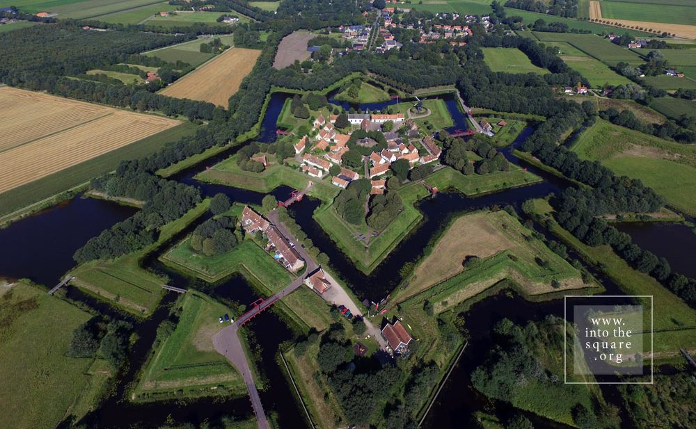
Today this is a village, with 133 houses and fewer than 300 inhabitants. Yet Bourtange was built as a military fort in 1593, during the Dutch Revolt, on the orders of William the Silent. It held this role until 1851, when it officially lost its defensive function and became populated by craftsmen and farmers. Its initial purpose was to guard the road linking Spanish Groningen to Germany. It is one of the most spectacular star-shaped forts in Europe. The pentagonal plan and its network of canals and fortifications respects the original project. The square stands in the geometric middle and follows the pentagonal shape of the buildings placed within the fort. Its perimeter is perfectly defined by 14 lime trees which are over 300 years old. The square holds the most important houses: the captain’s house, the commander’s house, and the house of the school headmaster, for the placement of its buildings was hierarchical. The Protestant church dates from 1869 and, notably, is situated close to the square but not within the square itself.
On the Portuguese side of the border there are even more fortifications than in Spain. Almeida is found in the north of Portugal. It is a star-shaped fort with 12 corners, Vauban style, built in 1641. The Spanish only entered there once in all their history, and then with the help of the French. The square is an irregular quadrilateral and is not positioned quite geometrically, just as the star is not perfect; but its role as a centre is obvious when viewed in relation to the margins of the citadel.
Coimbra is famous for its university, and monumental squares are located in the university area. The city also possesses a small jewel of a square, modest in size but convincing through its balanced proportions and its historical importance. It is Praça 8 de Maio, found in the city centre, in front of the monastery of Santa Cruz, while further on one finds the Câmara Municipal. This small space manages to not be dwarfed by the height and splendour of the Manueline façade of the church where the first two kings of Portugal lie buried. The buildings on the other three sides are just as visible, likewise the central fountain. The contemporary redesigning of the square also contributes to its openness.
At a short distance from the monumental Praça do Comércio stands the municipal square, which hosts three important buildings: the Municipality, the Court of Appeals and the Naval Arsenal. It is a small, quiet square, with different rhythms from the Praça do Comércio, which, following the Rua do Arsenal, stands less than 70 meters ahead. Praça do Municipio is equally part of the urban fabric woven from the city’s reconstruction under the guidance of the Marquise of Pombal. This historical detail is enough to make it clear that they must be understood as counterpoints, that is, as parts of a broader, interconnected system of squares.
This town took its name from Count Rodrigo González Girón. It was he who, in the mid-12th century, banished the Moors from this region once and for all, and built this town on top of a former Roman castrum, itself built atop a Celtic settlement. Its solid fortifications speak to its position on the border with Portugal. Paradoxically, although it is one of the most well-defended European borders on both sides, this frontier was the most stable in all of Europe’s history and has remained this way for 500 years. The only fighting to take place here was against Napoleon’s armies. Nowhere is the relationship between centre and periphery more marked than in such citadels.
The construction of this square began in 1729, by order of Phillip V, with the square primarily intended for bull fights. Today, it is seen as one of the most beautiful squares in Spain and in the whole of Europe. The space offers a paradoxical optical illusion. From the ground it appears to be a perfect quadrangle, but when seen from an aerial photo, the shape is irregular. The baroque façades of the building, which surround and define the square’s perimeter, seem perfectly symmetrical at first glance, but in reality, none of them are the same height. Entire books have been written about this square in Salamanca, and, to this day, it is considered the absolute model of Spanish squares.
Already from the 14th century, markets were constantly held in Piața Sfatului in Brașov and produce was exchanged. Back then it was called Marktplatz. The space is dominated by the Casa Sfatului, constructed in 1420. It not only forms the centre of the square, but also offers an interesting chromatic counterpoint, through its light colour, to the nearby Schwarze Kirche, the Black Church, visible from the square.
This square owes its existence to the great Lisbon earthquake of 1 November 1755 and the fire that followed. On this spot, abandoned due to natural disasters, a new, well-ordered city was built, as a result of reconstruction efforts coordinated by the Marquise of Pombal, the leader of the royal government.
Praça do Comércio was built on Terreiro de Paço, the site where the court of the Royal Palace had previously been held. This name is still used for the square, with its one side facing the Tejo, the greatest river on the Iberian Peninsula. Measuring 175 by 180 meters, this square is one of the largest on the European continent.
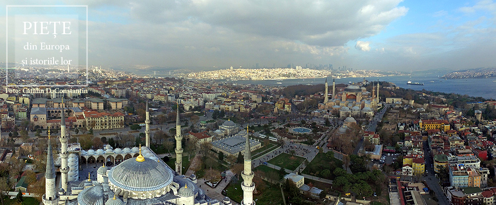
This square bears some of the ambiguity of the meeting point of the Orient and Europe. This is not a single square, but rather two squares brought together and identically named. Between the Hagia Sophia and Sultan Ahmet Camii, known as the Blue Mosque, lies a square with a fountain at its centre, often called Ayasofya Meydani, although the official name is Sultanahmet Meydani. It is a market-garden, built on the spot which held the Augusteion, the Roman forum of Augustus. Paradoxically, the long square between the Blue Mosque and the Museum of Islamic Art keeps the name Sultanahmet Park, although it is less of a park than the neighbouring square. There is no place in the world that brings together so much history. The obelisk of Theodosius the Great is, in fact, Egyptian, and was brought here in 390, from Luxor. Sculpted in Aswan granite, it was built in 1490 B.C. for the Egyptian pharaoh Thutmose III. The serpentine column was brought in 324 to the temple of Apollo at Delphi, where it celebrated the victory of the Greeks against the Persians. Cast from the alloy of the Persian weapons and melted down by the Greeks, it is now 2500 years old. Another obelisk was built in the 10th century by Constantin VII. One must also add the “German fountain” built in 1900 to mark the visit of Kaiser Wilhelm II. Then, there is the Art Nouveau façade, with the Oriental features of the building, which is now houses the rectorship of Marmara University. The Blue Mosque and the Hagia Sophia define a side of the square. On the opposite side, the Museum of Islamic Art is found in the palace of Ibrahim Pasha, the vizier of Suleyman the Magnificent. A marble column marks the kilometre zero of the Eastern Roman Empire, still visible in the north-eastern corner of the square. And that is not all. The square is, in fact, the arena of the Roman hippodrome.
From a bird’s eye view, the old town of Split resembles a rectangular box into which someone has placed buildings, streets, and markets. Beginning in the Middle Ages, two of the larger markets in this citadel played a key role in the history of the city, Narodni Trg, or Spalato in Italian. The People’s Square, called simply Pjaca by the locals, was first mentioned in the 13thcentury, and has a number of superb Gothic buildings. A bit further on, at the entrance to the citadel, lies Trg Braće Radić, called Voćni Trg by the locals, meaning “fruit market,” in reference to its earlier, colourful identity. Just outside the medieval walls is a third great square, Republic Square. Its more recent architecture reminds one of Venice’s San Marco. It was built in the mid-19th century, in a historiciststyle, demonstrating that Split, long under Venetian rule, still carries on this tradition. These are beautiful squares, each with its own marked individuality, but the oldest and most interesting of the Split squares by far is Trg Peristril, which is smaller, yet considered by locals to be the historical heart of this area. Its history is special. Originally, this square served as the interior courtyard of a palace built for the Roman emperor Diocletian in 305, across a huge surface measuring 300 square meters. In fact, half of the old city of Split lies within the palace walls, the most well-preserved Roman palace today. After the Romans abandoned it, it remained uninhabited for centuries, until the people of Salona used it when taking refuge from the Slavs, turning this former palace into their settlement. And a settlement it shall remain. John of Ravenna, the first local archbishop, oversaw the transformation of the Diocletian mausoleum into a church. This was the moment when the palace courtyard officially became the Cathedral square, with all of the functions of a medieval square. Changes were made to it, but some features were kept, including its red porphyry columns.
The history of this city is tied to Venice, but Rovinj was built much earlier, at the start of the 8th century, on an island separated from land by a narrow canal. Much later, in 1763, towards the end of Venetian rule, the community silts the isthmus and the city is united with the mainland. Through a classic process of synoecism, a new system of markets takes shape right on the spot of the old canal. They are four in number, and the most important is Trg G. Matteottija. Most of the buildings here are from the 19th century, but they celebrate the past link of the city with Venice, even recreating the lion of San Marco on the city hall’s pediment. The main square of the city remains Trg Sveta Eufemije, found at the highest point on the hill. Unobstructed on three sides, it gazes out to the sea, dominated by the 60 meter campanile of the basilica, with the statue of Saint Euphemia at the top, rotating in the breeze.