Kroměříž is first mentioned in 1110. It has a large square, whose focal point is a baroque-style column raised in the middle in order to mark the end of the plague epidemic in 1680. Next to it there is a fountain, part of the town’s water supply, dating from 1665 yet modified several times. The City Hall building and a long row of Renaissance style houses and Art Nouveau façades border the square; yet the bishop’s palace, with its large, splendid gardens, included on the UNESCO heritage list, is clearly the most impressive of all.
La plaza de Naarden no tiene nada especial, no obstante el conjunto en si es espectacular. Se trata de un espacio muy grande, irregular, edificado alrededor de la iglesia de ladrillo rojo Grote Kerk, construida en el estilo del gótico nórdico de siglo XV y consagrada a San Vitius antes de la reforma protestante. La iglesia es, sin embargo, una de más antiguas de los Países Bajos que sorprendentemente ha sobrevivido a los incendios provocados por la justificada invasión española de 1557. En un lateral de la iglesia, en la plaza, está la estatua de Comenius, nacido en el burgo de Naarden. En una esquina se encuentra el edificio renacentista del ayuntamiento, decorado profusamente con figuras humanas alegóricas. Markt es el centro de una fortificación en forma de estrella, rodeada por una doble hilera de zanjas llenas de agua.
La ciudad conserva restos de las sucesivas murallas que rodeaban el centro y que fueron demolidas durante el siglo XV, visibles ahora por las “muurhuizen”, casas-muralla, hechas con adobe. Fuera de la ciudad vieja, se han desarrollado suburbios lineales a lo largo de las vías principales. Con el tiempo, el espacio entre éstas y la ciudad se ha llenado y la ciudad se extendió posteriormente más allá, pasando la autovía. Su centro sigue siendo la plaza Marktplein de Hof.
Šibenik is no exception among the towns on the Dalmatian coast. It did not originate as a Greek colony, nor was it founded by Illyrians or Romans, but by the first Croats to settle here. Yet its later history is not very different from that of other coastal towns, impacted by the arrival of the Ottomans, the Venetians, the Kings of Hungary and the Habsburgs. But the Slavs always remain the dominant element in the citadel. For a time, the Istro-Romanian community was numerous here.
The square has distinct nuances and is considered the most beautiful in present-day Croatia. It contains two sections, one of which was the church square, whereas the other was the centre of secular power and, although close to the shore, it was never a port. The important landmarks of the square are the Renaissance-style palace, and especially the Church of St. Jacob, which is part of the UNESCO list.
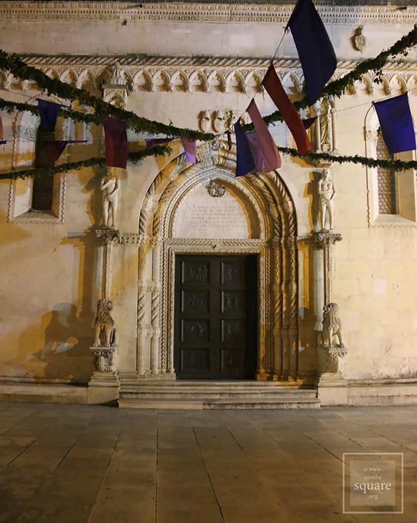
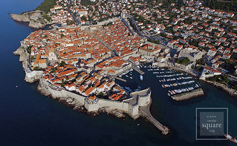
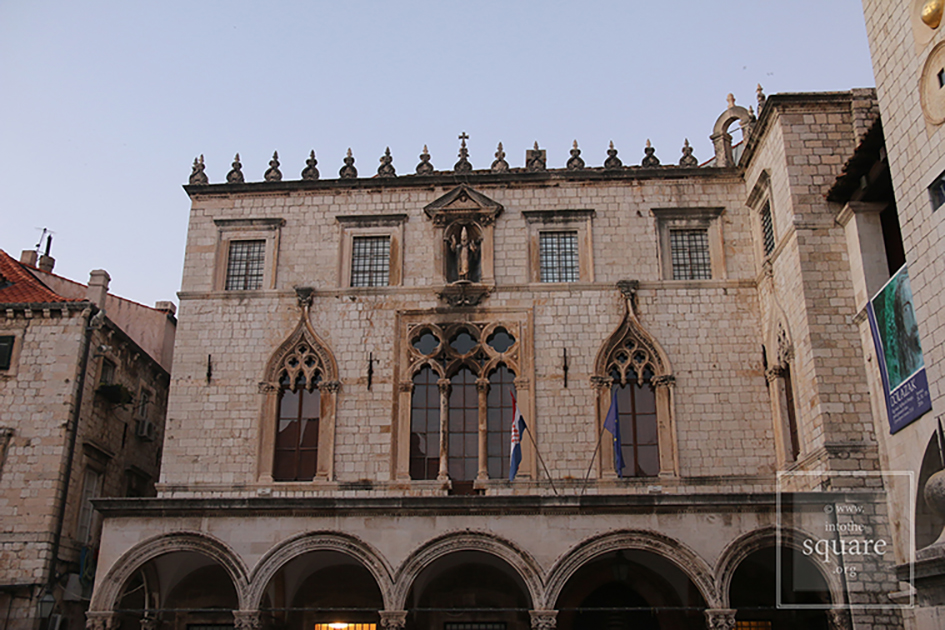
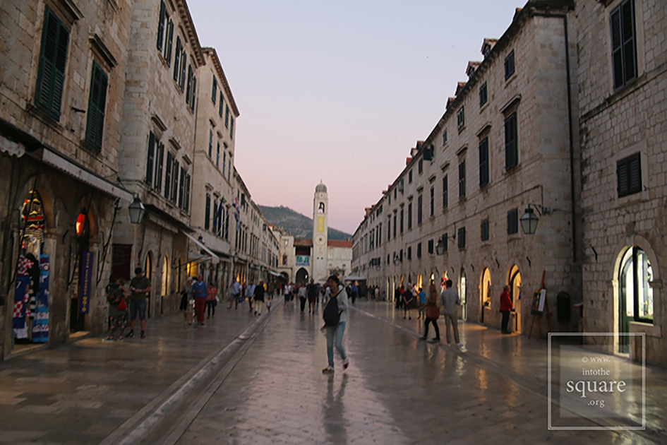
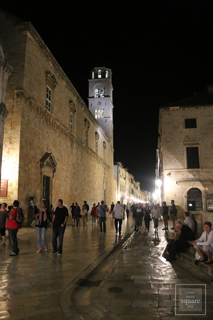
Trg Luža, la gran plaza de Dubrovnik, se encuentra al final de la arteria más ancha que cruza los límites urbanos de oeste a este, llamada Stradun o Placa. Cada extremo representa un punto de entrada a la ciudad, marcado por una puerta y una plaza. Esta estructura, claramente visible en fotografía aérea, está relacionada con el nacimiento de la ciudad. Diez siglos atrás, Stradun era un canal que separaba la antigua colonia greco-romana de Ragusa, ubicada en una isla, del asentamiento eslavo en el continente, Dubrva. En el siglo XI, el canal se colmata y las dos comunidades se unen, aunque la rivalidad y el desprecio mutuo nunca cesarán. Un siglo después estarán dentro de las mismas murallas. Siguiendo el esquema clásico del proceso de sinocismo, la plaza principal se configura en el punto de contacto geográfico de las dos comunidades. Así nació Trg Luža y aquí se construirán a lo largo de su historia los edificios más importantes: la catedral, la estatua de Orlando, el Palacio del Rector, el Palacio Sponza, la Torre del Reloj y la pequeña fuente de Onufry. La calle de la fuente une la plaza Luža con la plaza Gundulićeva Poljana, mucho más tardía, construida después del terremoto de 1667. Las dos, aunque pensadas por separado, forman sin embargo un sistema de conjunto muy interesante y destacable.
Assisi,famous due to Saint Francis, is, through its positioning, yet another exception to the rule of Etruscan settlements. It lies not on a hill, but on a steep side of Mount Subasio. It also holds its own “secrets”. For one, its shape, irregular like any medieval square, represents the shape of the town in miniature. A coincidence, yet a profoundly symbolic one in the town of Saint Francis. Then, it has a special continuity, for it stands on the site of a Roman cistern. The temple of Minerva also dates from the Roman period, converted into a church in 1539 and admired for its proportions by architects and by Goethe as well. Although not planned this way, the buildings are all nearly the same height, which creates the sensation of unity. There is a single exception, the medieval tower next to the temple of Minerva, which makes the square visible from any corner of the town.
San Marco Square lies at the edge of the largest and lowest island in the Venetian lagoon and is the only square in the city which is called piazza, with all the others being called campo. It has two distinct zones, yet their function may not be understood without considering the whole, which actually makes them inseparable: the square itself and the San Marco plaza, which connects to the sea through the molo, the pier. Piațeta dei Leoncini, with a side marked by the northern wall of the Basilica, opposite to San Marco square, has functioned (and still does) as a continuation of the square itself, and thus has a less palpable identity. It received its name quite late, after statues of lions, sculpted from red Cottanello marble, were brought into its centre in 1722. The initial nucleus is essentially represented by San Marco plaza, initially planned as a square and courtyard of the Doge’s Palace in a time when the spot of the current Basilica was taken only by a palace chapel. The space of the square itself appeared only after the 1156 clogging of a river which cut the actual perimeter in two, and the square became a Square only after Venice underwent a number of historical changes, the steps of a communal psychological transformation. Today it is probably the most photographed square in the world, with over 12 million tourists every year.
The history of Aristotelous square began with a fire that destroyed two thirds of the city in 1917. Until that point – due to centuries of Ottoman rule – Thessaloniki was an Oriental city, with no square. Moreover, any attempt to design one had been thwarted by the impossibility of demolishing an area which had been built too densely. However, what cannot be achieved by architects can be accomplished by fire. The project was prepared by Frenchman Ernest Hébrard in 1918, but finalised only in 1950.
Herceg Novi (Castelnuovo in Italian) is not new as the name claims, but rather quite old, for it was founded in 1382 on the site of a fishing village by the Bosnian King Stephen I, which is also the name of this town’s central square. The Turks conquered the town in 1482 and remained there for two centuries, with a brief Spanish interlude. The town came under Venetian rule in 1687, then passed to Austro-Hungary. After that, Herceg Novi was temporarily ruled by Napoleon, the Russians, and Mussolini, and then became part of Yugoslavia. Its history, though not in its entirety, can be found in its square. It is paradoxical square, for it was built in a typically Italian style, with a splendid Orthodox church in the middle, surrounded by palm trees. Unofficially, the name of the square is Belavista. From there the sea is visible, as well as an Ottoman clock tower, a Spanish fortress, the bell tower of the Catholic church and the lower part of the city.
Náměstí Svornosti is a small, 45 x 60 meter square. Beautiful but unexceptional, grouping a number of houses with Renaissance façades, it has a baroque column and is bounded on one side by the arches of the old City Hall building. The town, called Krumau in German, grew around the splendid castle, whose first historical mention is encountered in a 13th century poem. The castle has always remained the focal point, whilst the square held a secondary role, which accounts for its size, also determined by its location on a bend of the Vltava river. But it too remains a key element in the fairy-tale like atmosphere of the settlement, which has become renowned across the world and, thus, invaded by far too many tourists for such a small town.
La plaza de Elburg es el resultado de la intersección de las dos vías principales urbanas y representa, a una escala mucho más reducida, el cuadrilátero del mapa de la ciudad. Elburg tiene un estructura geométrica perfecta, diseñada bajo la proporción aurea del número de oro. La planificación de la ciudad, conservada sin ningún cambio, se realizó entre 1392 y 1396 y es una excepción para la Edad Media.
This square has an important role in the social and economic life of the Leira community, for it is filled with cafes and terraces, where numerous events are organised. The square’s pavement is considered one of the most beautiful in Portugal. In medieval times, the square held seasonal fairs.
This is a square filled with life, bars, shops, taverns, terraces, restaurants. Built between 1821 and 1851 in a neoclassical style and surrounded by identical buildings, with three levels and a colonnade, it is called Plaza Nueva, in contrast to the city’s medieval square, and measures 3400 square meters. The functionalist style of its buildings and the absence of rich decoration reflect the ideas of the Enlightenment, for the square was planned at the end of the 18th century, although its construction began a few decades later. The first architect of the square was Silvestre Pérez. The space gives one the feeling of a giant yet intimate palace salon. Every Sunday, Plaza Nueva hosts a flea market.
This square is among the largest in Europe, and bears the name of King Ottokar II of Bohemia, who in 1256 founded the town, called Budweis in German. The Black Tower, built in the 16th century, and the Cathedral of Saint Nicholas are found in its south-eastern corner. The Baroque City Hall building lies at the opposite corner of the square, whilst its central point is occupied by Samson’s Fountain, featuring elaborate Baroque decorations. Completing the square are 48 houses with coats of arms; a beer factory; and a salt market.


 The functionalist style of its buildings and the absence of rich decoration reflect the ideas of the Enlightenment, for the square was planned at the end of the 18th century, although its construction began a few decades later. The first architect of the square was Silvestre Pérez. The space gives one the feeling of a giant yet intimate palace salon. Every Sunday, Plaza Nueva hosts a flea market.


