Legend has it that whenever they wanted to build a village, the wandering shepherds of the Pindus chose a place and planted a tree. If the tree – which they passed by at least twice yearly with their herds – grew well, they would build a settlement there, with the tree as its heart. All of the Aromanian settlements in the Pindus have a square and all of them have an ancient tree at their centre. The locals call the square the plateia, platia, mishori or mesohori. These contain all the important buildings in the life of the community. The church, the school, the fountain, the cafes, all of these are found in the square. Or, rather, they define the square. Where they are the square is as well. It is a spatial, architectural definition, but especially a social and anthropological one, for this is the place where all important community events take place. For this reason, before having an architectural definition, the square has an anthropological definition. These are not squares meant to be seen, but squares where things are meant to happen. Their main function is not aesthetic, but social. And what happens, in brief, is the story of the community, which must function as a whole.
Per le città europee la piazza è il luogo più significativo. È lì che convergono le vie più importanti e che si trovano gli edifici e le statue più rappresentative. La piazza di una città europea è un riassunto: storico, architettonico, culturale, sociale. Nella piazza di una città si rivelano spesso simultaneamente tutti gli strati della vita umana, a livello individuale e sociale. Da questo punto di vista, la piazza è uno spazio privilegiato. Un palinsesto che parla, se lo si sa interpretare, delle varie epoche della storia e della vita di quell’insediamento.
La storia delle piazze europee è legata con un filo storico continuo all’Antichità greca, dove appare prima la plateia, poi l’agora. La piazza urbana è specifica per l’Europa, le altre culture non ne possiedono una così lunga continuità, sebbene le piazze esistano pure lì, alcune pure molto vaste. L’Europa ha inventato la piazza, l’ha sviluppata come forma architettonica, per esportarla poi nel resto del mondo, soprattutto nel periodo coloniale.
Πορεκ, Κροατία
Mentre inizialmente si presentava come un mero ampliamento della via principale delle polis greche, col tempo la piazza acquista compiti comunitari e religiosi e comincia ad essere abbellita. Dai greci passa agli architetti romani, che rendono il foro essenziale nel pensare lo spazio. Dopo la caduta dell’Impero romano, la vita urbana ritorna in Europa appena intorno all’anno 900, quando molti dei borghi medievali si sviluppano sugli insediamenti romani, conservando la loro planimetria e struttura stradale, dove al posto del foro subentra la piazza centrale, come avviene a Zdar o Poreč sulla costiera dalmata.Se fotografata dal drone, qualsiasi città medievale rivela la fondamentale opposizione tra il margine e il centro, perché le città medievali sono sempre circondate dalle mura. Alcune, come Óbidos in Portogallo, conservano intatte al giorno d’oggi queste fortificazioni. La piazza è uno spazio ampio, che si oppone come volumetria alle strade sempre strette e tortuose delle città. È quasi d’obbligo che nella piazza centrale si trovino la cattedrale e una fontana. Nel caso delle città piccole, la fontana ha anche un ruolo funzionale. Nel caso di quelle grandi, il ruolo è uno meramente estetico: la presenza della fontana è un riflesso della tradizione, del costume.
Όμπιδος, Πορτογαλία
L’esistenza delle mura ha generato delle conseguenze significative per le città di tutta l’Europa occidentale. Prima di tutto, lo spazio limitato ha fatto sì che, per secoli, la popolazione rimanesse numericamente costante all’interno delle mura. Quando la popolazione cresce, è preferibile fondare un nuovo insediamento invece di allargare la cinta muraria. La costruzione inizia sempre dal centro, dalla piazza, quello è il posto che viene stabilito per primo. Una seconda conseguenza importante dell’esistenza delle mura: il centro rimane sempre lo stesso. In questa comunità, la piazza si sovrappone di solito al centro geometrico, che era lo spazio più protetto. Là il nemico arriva per ultimo. Poi, l’accesso in città si fa attraverso alcune porte e, per forza, tutte le strade portano fino alla piazza centrale. La prospettiva aerea mostra come la piazza sia il punto di focalizzazione della città medievale. Le mura segnano nel modo più ovvio il rapporto di opposizione del centro con la periferia. Da qui deriva nel tempo un’altra conseguenza: quando, agli inizi della modernità, le mura vengono abbattute, queste città tendono a svilupparsi non in maniera lineare, bensì concentrica, aggiungendo delle fasce successive ad una struttura preesistente, ancora visibile, d’altronde, in molte delle città europee odierne.
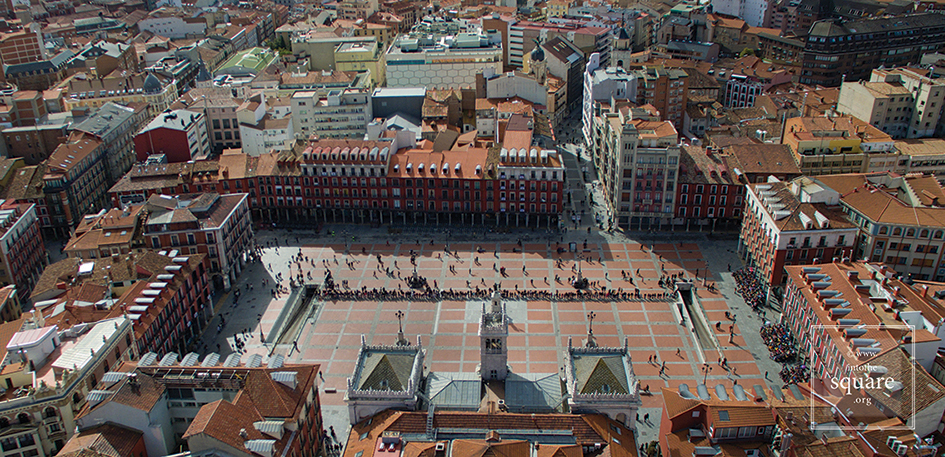
Βαγιαδολίδ, Ισπανία
Nel Rinascimento, l’Europa riceve in eredità le città medievali, alle quali non è più affezionata e che vuole cambiare: nell’ambito di certi limiti costruiti, l’Europa immagina diversi mondi urbani. Questo periodo, tuttavia, non resta nella storia per la costituzione di città reali, quanto per quella di città fittizie. Quando tuttavia la storia pasa dalla teoria alla pratica, ciò avviene piuttosto in seguito a delle calamità. Il 21 settembre 1561, un grande incendio colpisce la città di Valladolid. Quello che per la città è un disastro, è per l’urbanistica una grande opportunità. Nello spazio rimasto vuoto viene costruita la stupenda Plaza Mayor, che resta tutt’ora una delle più grandi di tutta la Spagna. È la prima piazza regolare dell’Europa, oggi ingiustamente misconosciuta come tale. La sua pianta simmetrica si nota benissimo dall’alto. Il modello architettonico e urbanistico istituito a Valladolid viene in seguito ripreso da varie altre piazze e tocca la perfezione nel 1729 con la Plaza Mayor di Salamanca, una delle più belle del mondo. Sempre e solo dall’alto si nota subito che il suo perimetro non è quadrato, ma trapezoidale. All’altezza dello sguardo, chiunque percepisce la piazza con i lati perfettamente paralleli e uguali: una sottile illusione ottica, attentamente calcolata per aumentare la prospettiva e aumentare lo spazio relativamente piccolo che l’architetto ebbe a disposizione.
Σαλαμάνκα, Ισπανία
A cominciare dal Cinquecento, le città continuano ad avere le mura di cinta, ma queste vengono pensate diversamente. Sempre di più, il compito di progettare il disegno della città passa dall’artista architetto all’ingegnere. Il momento fondamentale di questo cambiamento viene segnato nel Seicento e collegato al nome di Vauban. Il tipo di fortificazioni che lui propone ha come scopo di far stanziare all’interno della cinta muraria fortificata un grande numero di soldati. I forti a forma di stella si diffondono rapidamente in Europa, da Naarden e Bourtange in Olranda, fino ad Alameida in Portogallo o Alba Carolina in Romania. Queste città militari hanno una struttura perfetta, con vie rette che portano per forza verso una piazza larga, collocata al centro. A livello dello sguardo normale la perfezione dei forti si lascia semmai intuire, anche perché gli edifici sono spesso austeri. Ciò nonostante sono di gran lunga i più belli insediamenti del continente se fotografati dall’alto, come altrettante stelle adagiate per terra. Mai come in questi casi risulta così evidente l’importanza della piazza come spazio centrale.
Νάαρντεν, Ολλανδία
A partire dalla metà del Settecento e lungo l’Ottocento, le città si reinventano in un modo che riflette i cambiamenti militari, tecnologici e politici. L’autorità delle città-stato era già sminuita da un bel po’ di tempo, fino a scomparire completamente di fronte all’autocrazia dei monarchi. Questi aprono l’accesso in città dei soldati, i quali hanno bisogno di vie rette: per un’azione veloce, ma anche per presentare le loro parate. La nobiltà comincia ad abbandonare le residenze fuori città, vuole stare più vicina ai centri del governo e si fa costruire dei palazzi in città. Col tempo questi ne diventano la residenza di base. Indi, molti dei nobili cominciano ad essere interessati a come si presenta la città, sicché i piani di queste cambiano radicalmente. Cambia inevitabilmente il senso delle piazze e il loro rapporto con il resto dello spazio. Laddove gli insediamenti medievali avevano una struttura basata sui bisogni dell’intera comunità, ora le città si modificano per corrispondere al gusto degli aristocratici. Nell’ambito dell’estetica urbana avvengono trasformazioni essenziali. Quando le strade diventano rette, la prospettiva si apre, la gente comincia a vedere a distanza, al di là del primo angolo della strada. Da qui fino al concetto di vista manca solo un passo. La vista, sconosciuta all’Antichità classica, suppone un concetto urbanistico molto più complesso: i monumenti e le statue non vanno viste soltanto da vicino, esse rappresentano un punto di riferimento quando si trovano alla fine di una via lunga e retta che permette all’occhio di penetrare nella piazza anche da lontano. Quello che prima era un effetto scenografico casuale, ora diventa un argomento di studio. Gli archi trionfali, le colonne commemorative, le statue sono costruite e collocate in modo da essere belle anche da lontano. Da qui alle arterie che attraverseranno le città come altrettanti corridoi celebrativi manca solo un passo. Se guardata dall’alto, Lisbona rivela le trasformazioni coordinate dal marchese di Pombal, dopo il devastante terremoto del 1° novembre 1755. Le piazze della città rappresentano un vero e proprio sistema: larghi viali retti collegano la Piazza del Commercio a Rosio, Rosio a Figueira, Martim Moniz a Restauradores, Restauradores a Praça do Marquês de Pombal, e in mezzo a ciascuna di queste troneggia un monumento significativo.
Λισαβόνα, Πορτογαλία
Non bastano gli edifici per far esistere una piazza. Le città sono un amalgama di persone e di edifici e il rapporto fra i due elementi non è tanto chiaro quanto possa sembrare alla prima vista. Le persone costruiscono gli edifici e il modo in cui una comunità sviluppa nello spazio la propria storia, religione, fede di qualsiasi tipo, i bisogni concreti della vita quotidiana non è, ad oggi, molto chiaro: tante sono le sfumature di questo complesso processo che ci sfuggono e forse mai si lasceranno descrivere fino in fondo. Una piazza ha la sua propria architettura ma, allo stesso tempo, rappresenta più della sua architettura. L’intero passato, concatenato in un sistema di rapporti visibile-invisibile con l’immaginario simbolico della collettività, si fa notare nell’esistenza della piazza.
The construction of this square began in 1729, by order of Phillip V, with the square primarily intended for bull fights. Today, it is seen as one of the most beautiful squares in Spain and in the whole of Europe. The space offers a paradoxical optical illusion. From the ground it appears to be a perfect quadrangle, but when seen from an aerial photo, the shape is irregular. The baroque façades of the building, which surround and define the square’s perimeter, seem perfectly symmetrical at first glance, but in reality, none of them are the same height. Entire books have been written about this square in Salamanca, and, to this day, it is considered the absolute model of Spanish squares.
Perched upon a hilltop in Tuscany, Pienza was originally called Corsignano. Pope Pius II loved his hometown greatly and wished to transform it into a concrete illustration of his theories about the “ideal city.” For this purpose he hired the architect Bernardo Rossellino and was himself directly involved in the city’s planning. Influenced by Alberti’s writings, Pius wished to build a uniform and self-sufficient city around a central square. Yet when he died in 1462, the urban sketch of the city that had taken his name was stopped, with only 40 completed buildings. At the heart of this “ideal city,” Bernardo Rossellino had managed to install a trapezoidal square, representing one of the first attempts of urban renewal in the postclassical period.
The area is not large, yet the illusion of space is created through its shape and the design of the pavement. The overall effect is that of a stage set flanked by important buildings. The Palazzo Vescovile lies on the eastern side of the square. On the opposite side stands the Papal Palace. The City Hall lies to the north, with a Florentine-style tower chosen by Rossellino. Two other buildings complete the northern side next to the City Hall. The square is dominated by the façade of a Cathedral, built along the smaller side of the trapezoid, so as not to end up overwhelming the square, for the Pope wished to build a city of human, rather than monumental, dimensions. Everything was carefully calculated, with the construction of the church even taking the movements of the sun into consideration. Inspired by Austrian Cathedrals that were bathed in natural light, the Pope asked that this church not respect the traditional east-west alignment, but be set in such a way that the sun would pour in from the southern windows. The church is aligned with the top of Mount Amiata, an extinct volcano. Its peak is visible from the southern windows of the church, though it is not visible from the square. This leads to an interesting reversal of perception: the interior of the church feels like a wide space that opens out to the landscape, while the square allows little access to its surroundings, and instead feels like an interior space. The two narrow open areas inside the square, on either side of the Cathedral, are some of the earliest Renaissance examples of visual access to rural landscapes from within a town. As such, it diverges from traditional medieval squares. In order to see the landscape, one must arrive at the very end of the square.
Within the square, various details from one building’s façade reappear on another façade; the rectangular shape of these façades recreates the shapes of the windows to scale. The windows at the upper level of the Papal Palace are Rossellino’s inventions, a combination of the Roman cross and the Tuscan rose window. The cross reappears as a detail on the windows of the Palazzo Vescovile, and the rose window reappears on the City Hall’s windows. Archways and circular details, grouped in threes, repeatedly appear on the façade of each building, The travertine grid and the red brick pavement mirror the series of compartments on the façade of the church, and are aligned with the pillars, doors, and corners of all of the buildings found along the square. At the centre of the square is a travertine circle, and the distance between the circle and the door of the church is equal to the distance between the base of the church and the occhio, a typical round window on the façade of the church. This is not the only “coincidence,” for the square respects a geometry based on the numbers 3, 5, and 9. Moreover, in the early 2000s it was found that the shadow of the Cathedral aligns perfectly with the grid of the pavement at particular moments in time—specifically, 11 days after the solar equinox. It was known as early as the 15thcentury that there was an 11-day difference between the civil calendar and the astronomical one. The calendar reform was highly controversial within the Catholic Church, since Easter is calculated according to the equinox. Pieper, who observed the alignment of the church’s shadow with the grid, believed that the square was initially intended to demonstrate this on the day of the equinox. Thus, the construction had begun, but the project was adjusted so that the alignment would take place on the exact day of the equinox. When the modification was decided, construction on the square’s buildings was already underway. Redrawing the pavement grid would have led to discrepancies in the buildings’ details, so a solution was found by raising the roof of the Cathedral. This has been confirmed by evidence that the Albertian proportions on the church pediment have not been respected. It is still a mystery why details of this reconstruction, as well as the story of the alignment of the Cathedral’s shadow with the drawings on the pavement, make no appearance in the Pope’s extremely detailed diary.
Every other year, in the second week of September, Marostica hosts a game of chess. But in this game, living people play the roles of the wooden figurines, and the square of this tiny medieval town serves as the chess board, with its pavement designed especially for this purpose. For this reason, the Maroustica Piazza Castello is also called the Piazza degli Scacchi. As the story goes, in medieval times, two young nobles, Rinaldo D’Angarano and Vieri da Vallanora, fell madly in love with Lionora, the daughter of a local Lord. The customs of the time required that the girl’s fate be decided through a duel. But as her father did not wish to make enemies, and wanted no blood spilt, he forbid the duel and proposed a chess game in its stead. The winner would become the husband of the coveted Lionora. The loser would not lose, but instead gain the hand of his younger daughter, Oldrada. Of course, this story has no basis in historical fact. Not one of its characters ever existed, just as there was no chess match in medieval Marostica, which in the local Venetian dialect was called Maròstega. A Dalmatian writer and architect named Mario Mirko Vucetich invented the entire story, just after the Second World War. And the local chess club found it apt to regard the story as true and to organise, every other year, a competition with living people as chess pieces, in this scenic square with medieval origins in the small town of Marostica, in northern Italy.
Already from the 14th century, markets were constantly held in Piața Sfatului in Brașov and produce was exchanged. Back then it was called Marktplatz. The space is dominated by the Casa Sfatului, constructed in 1420. It not only forms the centre of the square, but also offers an interesting chromatic counterpoint, through its light colour, to the nearby Schwarze Kirche, the Black Church, visible from the square.
One one side of this square is a statue of Jan Žižka, leader of the Hussite movement, and one of the few military commanders in history to have never lost a single battle. Today, his name is found in this square in Tábor. Situated on a hilltop, with the square at its peak, and near Lake Jordan, named after the Biblical river, this city was founded in the spring of 1420 as a centre of the Hussite revolutionary movement. At first carefully planned, it later developed organically, and the shape of its square points to this tendency. Its streets were intentionally designed in zigzag formation, so that enemies would have difficulty reaching the centre. Although it is hard to see in the photograph, the square is sloped, which gives it an additional spatial dimension.
This square owes its existence to the great Lisbon earthquake of 1 November 1755 and the fire that followed. On this spot, abandoned due to natural disasters, a new, well-ordered city was built, as a result of reconstruction efforts coordinated by the Marquise of Pombal, the leader of the royal government.
Praça do Comércio was built on Terreiro de Paço, the site where the court of the Royal Palace had previously been held. This name is still used for the square, with its one side facing the Tejo, the greatest river on the Iberian Peninsula. Measuring 175 by 180 meters, this square is one of the largest on the European continent.
Soon after the Plaza Mayor was built in Madrid, its design was copied by other cities, even ones very distant from the capital. The Plaza de la Corredera in Córdoba is the only quadrilateral square in the south of Spain and Andalusia, developed by the architect Antonio Ramós Valdés of Salamanca. In 1683, on the site of an esplanade, which historically had been a Roman circus, and subsequently a trading area during the city’s Muslim era, he constructed a giant, semiregular quadrilateral, slightly smaller than the one in Madrid.
After it was built, the square was used for various purposes, serving as the grounds for temporary trade fairs and an arena for corridas, from which its current name originates. In the area beneath its ground floor arches are the so-called esparterías shops that sell traditional objects braided from plant fibres. Antique shops have existed here for nearly a century.
This urban structure was determined by its geographical position, one of the most spectacular in urban Europe. Passau is situated on a spit of land, at the confluence between the Danube, the Inn and the Ilz, each with differently coloured waters. The Domplatz lies at the highest point of the city, which serves to its advantage, as Passau is threatened by floods each year. The square was built in 1150, and in 1155, after donations by the Bishop Konrad von Babenberg, it became the property of the Cathedral, under the condition that clerical houses be built on its free sides. These 14 buildings were damaged by the great fires of 1662 and 1680, and then rebuilt by Italian architects in a late-Baroque style. In 1824, a statue of Emperor Maximilian I of Bavaria was placed in the square. Thus, for the first time in its history, the square became public, gaining the status of an official town square. It was renovated after 2013. Its pavement was replaced with fine gravel, pointing to its previous historical eras. Its lighting is spectacular, one of the finest in Europe. Highlighting the façade of the Cathedral, leaving the square and the rest of the buildings in half-light, it enngages in a subtle game of darkness and light, linking the past, when cities did not have public lighting, with the future. The effect is that of a scene from a Baroque play.
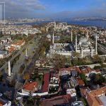
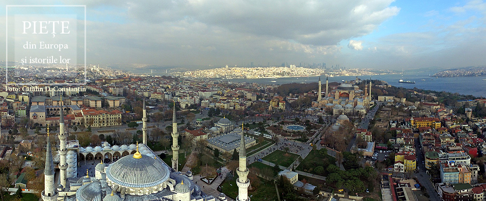
This square bears some of the ambiguity of the meeting point of the Orient and Europe. This is not a single square, but rather two squares brought together and identically named. Between the Hagia Sophia and Sultan Ahmet Camii, known as the Blue Mosque, lies a square with a fountain at its centre, often called Ayasofya Meydani, although the official name is Sultanahmet Meydani. It is a market-garden, built on the spot which held the Augusteion, the Roman forum of Augustus. Paradoxically, the long square between the Blue Mosque and the Museum of Islamic Art keeps the name Sultanahmet Park, although it is less of a park than the neighbouring square. There is no place in the world that brings together so much history. The obelisk of Theodosius the Great is, in fact, Egyptian, and was brought here in 390, from Luxor. Sculpted in Aswan granite, it was built in 1490 B.C. for the Egyptian pharaoh Thutmose III. The serpentine column was brought in 324 to the temple of Apollo at Delphi, where it celebrated the victory of the Greeks against the Persians. Cast from the alloy of the Persian weapons and melted down by the Greeks, it is now 2500 years old. Another obelisk was built in the 10th century by Constantin VII. One must also add the “German fountain” built in 1900 to mark the visit of Kaiser Wilhelm II. Then, there is the Art Nouveau façade, with the Oriental features of the building, which is now houses the rectorship of Marmara University. The Blue Mosque and the Hagia Sophia define a side of the square. On the opposite side, the Museum of Islamic Art is found in the palace of Ibrahim Pasha, the vizier of Suleyman the Magnificent. A marble column marks the kilometre zero of the Eastern Roman Empire, still visible in the north-eastern corner of the square. And that is not all. The square is, in fact, the arena of the Roman hippodrome.
From a bird’s eye view, the old town of Split resembles a rectangular box into which someone has placed buildings, streets, and markets. Beginning in the Middle Ages, two of the larger markets in this citadel played a key role in the history of the city, Narodni Trg, or Spalato in Italian. The People’s Square, called simply Pjaca by the locals, was first mentioned in the 13thcentury, and has a number of superb Gothic buildings. A bit further on, at the entrance to the citadel, lies Trg Braće Radić, called Voćni Trg by the locals, meaning “fruit market,” in reference to its earlier, colourful identity. Just outside the medieval walls is a third great square, Republic Square. Its more recent architecture reminds one of Venice’s San Marco. It was built in the mid-19th century, in a historiciststyle, demonstrating that Split, long under Venetian rule, still carries on this tradition. These are beautiful squares, each with its own marked individuality, but the oldest and most interesting of the Split squares by far is Trg Peristril, which is smaller, yet considered by locals to be the historical heart of this area. Its history is special. Originally, this square served as the interior courtyard of a palace built for the Roman emperor Diocletian in 305, across a huge surface measuring 300 square meters. In fact, half of the old city of Split lies within the palace walls, the most well-preserved Roman palace today. After the Romans abandoned it, it remained uninhabited for centuries, until the people of Salona used it when taking refuge from the Slavs, turning this former palace into their settlement. And a settlement it shall remain. John of Ravenna, the first local archbishop, oversaw the transformation of the Diocletian mausoleum into a church. This was the moment when the palace courtyard officially became the Cathedral square, with all of the functions of a medieval square. Changes were made to it, but some features were kept, including its red porphyry columns.
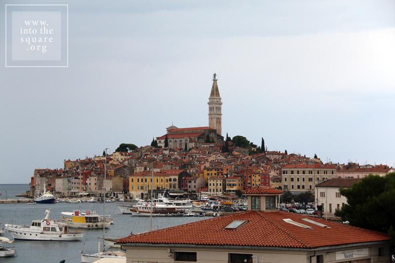
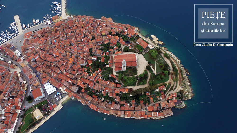
The history of this city is tied to Venice, but Rovinj was built much earlier, at the start of the 8th century, on an island separated from land by a narrow canal. Much later, in 1763, towards the end of Venetian rule, the community silts the isthmus and the city is united with the mainland. Through a classic process of synoecism, a new system of markets takes shape right on the spot of the old canal. They are four in number, and the most important is Trg G. Matteottija. Most of the buildings here are from the 19th century, but they celebrate the past link of the city with Venice, even recreating the lion of San Marco on the city hall’s pediment. The main square of the city remains Trg Sveta Eufemije, found at the highest point on the hill. Unobstructed on three sides, it gazes out to the sea, dominated by the 60 meter campanile of the basilica, with the statue of Saint Euphemia at the top, rotating in the breeze.
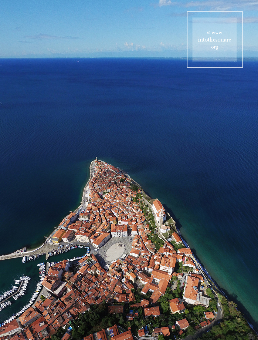
Giuseppe Tartini, author of the well known Il trillo del diavolo, was born in this city, then called Pirano, part of the Republic of Venice. The Piran square bears his name, and the birthplace of the composer can be found on one side of the square. At the time of his birth, however, the place looked completely different. Rather than a square, this area was first a loading dock for fishing boats coming in from the Adriatic, found outside the citadel walls . In time, palaces and beautiful administrative buildings were built closer to the piers. By 1894, the importance of the place grew enough that the authorities decided to silt the gulf and build a true square. Two years later, Tartini’s statue is unveiled, thought of as a focal point, and the square, dominated from the hill by the Saint George church and with a campanile identical to the one in Venice, is a harmonious and lively space, with a proper and accomplished balance of form and proportion.