Ljubljana, Σλοβενία, Prešernov trg, Mestni trg

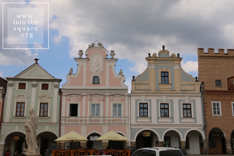
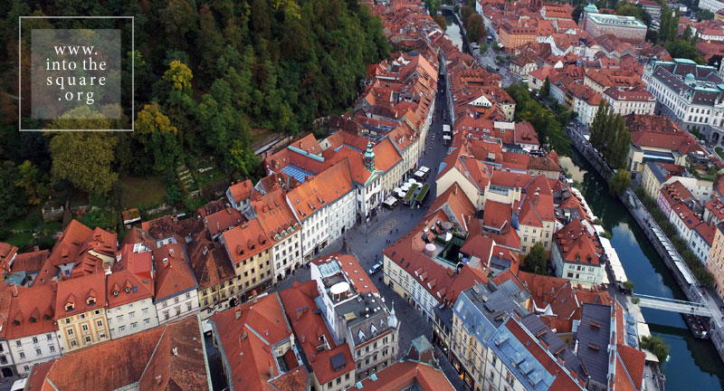
Το Prešernov trg ήταν ένα απλό σταυροδρόμι στην είσοδο της μεσαιωνικής πόλης, όταν, το 1646, χτίστηκε ένα φραγκισκανικό μοναστήρι που σώζεται μέχρι σήμερα. Τον 19ο αιώνα, το σταυροδρόμι πια στρωμένο με λίθους, άρχισε να μοιάζει με αστική πλατεία. Το τέλος του ίδιου αιώνα επέφερε έναν ριζοσπαστικό μετασχηματισμό, καθώς ένας σεισμός το 1895 είχε ως αποτέλεσμα τα παλιά σπίτια να αντικατασταθούν από νεοκλασικά κτίρια και αργότερα από σπίτια τύπου Sezession. Το 1980, ο Σλοβένος αρχιτέκτονας Edvard Ravnikar δημιούργησε τον σημερινό κύκλο σχεδιασμού του πεζοδρομίου, ο οποίος δίνει μια ιδιαίτερη πινελιά στην πλατεία: έναν ήλιο, σε γρανιτένιο υπόβαθρο, με ακτίνες από μάρμαρο Prilep. Μια τριπλή γέφυρα, η Tromostovje, απέναντι από τη Λιουμπλιάνα, συνδέει την πλατεία Stritarjeva ulica, με την παλιά πλατεία που βρίσκεται στους πρόποδες του λόφου όπου βρίσκεται και το κάστρο, δίπλα στον καθεδρικό ναό της πόλης. Η πλατεία κυριαρχείται από ένα σιντριβάνι χτισμένο το 1751. Τα δύο τετράγωνα, αν και δεν σχεδιάστηκαν μαζί, καθώς το καθένα ήταν εν μέρει το αποτέλεσμα μεταγενέστερων αναδιαμορφώσεων, αντιπροσωπεύουν ένα απροσδόκητα συνεκτικό και υποβλητικό αστικό σύνολο.

Hlavné námestie from Košice, Slovakia

Hlavné námestie means Great Square in Slovak, but the early history of this city and its central square is tied to the German colonists who arrived here in the mid-13th century, at the invitation of King Béla IV of Hungary. The city of Košice (Kaschau in German, Kassa in Hungarian, and Cașovia in the old Romanian chronicles), existed at the crossroads of great trade routes linking the Baltic Sea with the Black Sea; Poland with Transylvania; the east of Europe with the south of Europe. Its urban space is rigorously structured. Three parallel roads run from north to south, with the middle road becoming progressively wider until it meets the main east-west artery, forming a special, lens-shaped square. The lens shape is due to the construction of the square in a region that formerly functioned as a trade fair. The trade fair took place in a widened section of the road, halfway between a castle and an abbey, before any other buildings were constructed. The shape also comes from the unification, through a typical process of a synoecism, of two distinct pre-13th century settlements, whose borders were those of the present-day square. At its centre, where these two axes intersect, the German colonists erected a parish church. In the 14th century this church was replaced by the Gothic Cathedral of Saint Elisabeth, the largest Cathedral in Slovakia to this day. The tower of Saint Urban, containing a seven tonne bell, and the Chapel of Saint Michael, both Gothic and built in the 14th century, flank the Cathedral, creating a unique and unitary whole. The theatre, a Neo-Baroque jewel, was finalised in 1899. Gothic houses, Renaissance and Baroque palaces, and Art Nouveau buildings define the perimeter of the square. The contours of the old city walls are clearly visible along the circular paths of the adjacent streets. The lens-shaped square of Košice is the largest and most coherent urban ensemble of its kind, typical of eastern Slovakia.

Telč, Τσεχία, Náměstí Zachariáše z Hradce

Ιδρύθηκε το 1354, σε ένα πυκνό δάσος, στο σημείο όπου δύο δρόμοι διέσχιζαν δίπλα σε υδάτινες οδούς τα σύνορα μεταξύ Μοραβίας, Βοημίας και Αυστρία. Το Telč (ή το Teltsch στα γερμανικά) είχε την ατυχία να βιώσει μια μεγάλη φωτιά δύο αιώνες αργότερα. Η πόλη ανοικοδομήθηκε γρήγορα σύμφωνα με το αρχικό σχέδιο, αλλά με τροποποιήσεις που έλαβαν υπόψη την εξέλιξη των στυλ. Το γοτθικό κάστρο αναδιαμορφώθηκε στο αναγεννησιακό στυλ και κατασκευάστηκαν σοφίτες για τα σπίτια στην πλατεία. Οι οικίες απέκτησαν ζωγραφισμένες προσόψεις, οι οποίες αργότερα αντικαταστάθηκαν τον 18ο αιώνα με άλλες σε στυλ ροκοκό και μπαρόκ. Η μεσαιωνική γοτθική καμάρα στο ισόγειο παρέμεινε αμετάβλητη και συνεχής, ενώνοντας όλα τα σπίτια στην πλατεία. Δύο εκκλησίες και μια στήλη χτίστηκαν στην περίοδο της πανούκλας αφιερωμένα στον Άγιο Ιωάννη Nepomuk, πλαισιωμένη από δύο βρύσες. Προς τα τέλη του 18ου αιώνα, ο χρόνος σταμάτησε ξαφνικά στο Telč, με το τέλος της εποχής της δόξας και της οικονομικής ανάπτυξης. Η πόλη έφθασε στην εποχή μας χωρίς άλλες αλλαγές, ανεπηρέαστες από την εκβιομηχάνιση και, με κάποιο θαύμα, χωρίς σοσιαλιστικά μπλοκ. Είναι σαν να έχει βγει από ένα βιβλίο λαϊκών παραμυθιών. Ο χάρτης της πόλης είναι σχεδόν συνώνυμος με την τριγωνική πλατεία. Ένα βήμα έξω από αυτό μας μεταφέρει στα κίτρινα πεδία της ελαιοκράμβης των λόφων της Βοημίας.

Masarykovo náměstí from Třeboň, Czech Republic

Třeboň, or Wittingau in German, has one of the best-preserved medieval squares in Bohemia. In fact, only its shape dates from medieval times, since its current form, with its Renaissance and Baroque houses, resulted from the flourishing fish trade of the 14th century. Beginning in the mid-14th century, the natural landscapes around the city were gradually transformed by human intervention. The marshlands gave way to a dense network of over 500 lakes, grouped into 16 aquatic systems, today a paradise returned to the wilderness and populated with rare species of plants and animals. The largest of these lakes is located right near the city and is tied to the Rosenberg family, owners of the medieval burg. Like all historical cities in Bohemia and Moravia, this square contains a plague column; a Renaissance fountain; and a tower building belonging to the City Hall.

Náměstí from Štramberk, Czech Republic

Similar to many other small, out-of-the-way places, this square is simply called “Square,” or Náměstí in Czech. Štramberk is yet another example of a place where the entire town is condensed into its square. Aside from the row of houses that line its perimeter, only two or three additional streets complete the map. Trúba, a cylindrical tower consisting of the remains of a castle about which few things are known, dominates this settlement, perched on a nearby wooded hillside. Everything here reminds one of a fairy tale, from the forests to the castle to the square. A large number of wooden houses from the 18th and 19th centuries also add to the local cultural heritage. The land where Štramberk is located is called Valašsko, from the name of the populace who migrated here in waves, along the Carpathians from Transylvania and, perhaps, from Bukovina. Though the language of the Vlachs was lost along the way, and these people were slavicised, some customs did survive, such as the traditional building techniques that were adapted by local Czech and German craftsmen. The wooden houses clearly bring to mind the wooden Romanian architecture from Transylvania. A number of local settlements had such centres, but the wooden houses have been replaced by stone ones, usually Baroque in style. Štramberk has the greatest number of Vlach-style wooden houses, as they are called here, creating an interesting architectural reservation. Its square is also linked to the preparation of local cakes called “Štramberk ears,” which legally can only be made here. It is said that they have this name because the people of medieval Štramberk thought they resembled the ears of captured Tatar soldiers, during the time of the Tatar raids.

Hauptplatz from Retz, Austria

In 1278, count Berthold von Rabenswal receives from Emperor Rudolph I von Habsburg the right of ownership over the Hardegg land. He begins at once the building of a new settlement next to an existing village, called Rezze. He will follow a regular plan, in the style of Bohemian burgs, around a square that remains to this day among the largest in Austria, although the current population of the settlement numbers only 4000 people. The square is beautiful, with Italian inspired Renaissance palaces, fountains and a Baroque column of the Holy Trinity. In the middle stands the city hall, a former church, repurposed in 1569. But the bigger surprise lies beneath the pavement: under the square, under the entire town and even beyond lies a labyrinth of interconnected cellars, where the inhabitants have deposited local wine. It is over 20 km long, far greater than the network of streets above.

Piazza del Popolo & Piazza Garibaldi from Todi, Italy

Todi has three rows of fortified precincts. Following them towards the town’s interior, one climbs towards its square and descends into history, crossing medieval Roman and Etruscan walls. The square stands on the site of an old Roman forum, just as the Cathedral, which lies at the edge of the square and some steep steps, stands on the site of a temple to Jupiter. The Piazza del Popolo of Todi, a closed space dominated by massive crenellated buildings, conveys, along with its fortifications, a strong sense of protection. It is often cited in historical studies as the most convincing example of a medieval square. It is certainly beautiful and impressive. In the neighbouring Garibaldi Square, one crosses through a narrow passage that offers an unexpected surprise when it comes to the structure of the town. It shows the exact opposite: a side that is entirely open to the Umbrian hills.